Friday 27 February 2015

The Cateran Trail: Day 5 ~ Alyth to Blairgowrie


Royal Hotel, Blairgowrie


As expected, Day 5 began with porridge. And it was good.
I asked Eileen, & she told me you should soak the oats overnight to make it taste creamier. 
I have done this since (when I remember), & it really does work. Cheers Eileen :-q

We said Bye to John & he set off on his 16 miler. 
We went 6 miles in the other direction in a taxi. 

Fornethy House was owned by Glasgow City Council who sent kids there for a holiday. Hazel remembers going with her sister, & wanted to have a look & a reminisce.
The taxi man dropped us off at the edge of the estate, & we walked down the drive amidst evidence of tree felling. The house is now empty, but I don't think it's that long ago it was used.
Fornethy House


We walked right round it, peering into windows etc. Then we had a wander in the grounds & there was a broken wooden playground with an old seesaw & a swing Hazel remembered playing on. 

Out to the north of Fornethy Wood was a lochan. I don't think it was natural, as it was straight along the east edge, but Hazel remembered going swimming in it. 
Good grief! They'd* have a fit if you let kids do that now! Those Glaswegian kids were obviously toughies!
* "They" being those in charge of not letting kids have fun!


During our wanderings I took some pics of the spring flowers. It comes late up here.


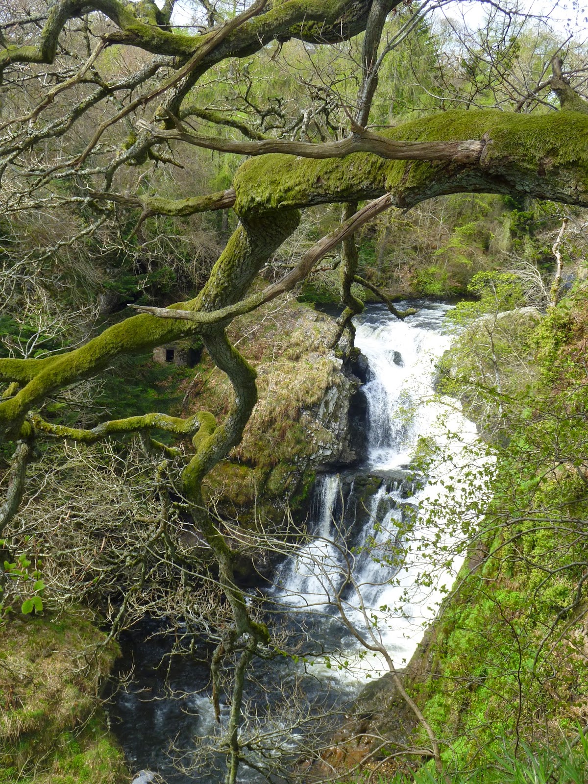
As we walked back to the main road along the drive, I managed to find the souvenir stick I'd been looking for, & stripped it of its bark & twigs while we walked to the B954 , & then south along it to Reekie Linn which is a fairly big waterfall just east of the road at Bridge of Craigisla. 
The bridge over the Isla at Bridge of Craigisla.
Stunt Day-sack & Stunt Stick give you an idea of scale ;-p


btw ~ Bridge of Craigisla is a hamlet & not just a bridge.
Left along the road goes back to Alyth & right takes you north to Dykends (great name) & the B951 to Kirkton of Glenisla ~ where we'd started the Trail the day before. 
After that the road heads back west past Forter, Dalnaglar & out to Lair ~ which is on the A93 due north of Bridge of Cally (which is also a village & not just a bridge).
Not sure if this is before or after the falls?
~ but the Isla's clearly in a hurry
The taxi man had told us to call him when we needed picking up, but we figured we should eat something here rather than in Alyth, & have another stop in Drimmie Woods later.
So we wandered along the river path & found a little plateau overlooking the falls.
Handily, there was also a fallen log which doubled as our seat.
After our muesli bars (again :-/ ), I had a wander a bit further along the path to see if I could find a good spot for some pics of the falls.
I got some pics of trees, too.
Well, I like trees as much as I like water, so I was loving it at Reekie Linn :-)
btw ~ Reekie is an old Scottish word for smoky or misty, & Linn is Gaelic for a deep or dark pool. So I suppose when the river is in spate, the mist over the pool beneath the falls would be misty with spray.
Dunno really: just my interpretation?
Shirley the tree-hugger.
Did I mention I liked trees?

The one above & this one's taken from our lunch plateau.
The Isla's cut a great gorge through the rock.


These next 2 were taken rather hanging out over the gorge. I think Hazel was having a quiet fit at my antics ;-p
Taxi-man was due, so I went for a quick paddle near the bridge, before we headed south along the road & our appointment with the Alyth taxi.
Another pic of the Isla gorge
He dropped us off at the other side of Alyth, near a place called the Den O'Alyth. This is a wooded area which drops down to a path along Alyth Burn. We met a horse being exercised there & said hello.

It was lovely there, in the woods & by the water :-D

The path climbed away from the burn & then we went left onto a little bridge (Bridge of Tully~ which is a bridge & not a hamlet!) before meandering uphill along a road to Drimmie Woods.
After >mile we ran out of road (well ~ the tarmac went sharp left, & we could see the path down to the woods straight ahead of us).
Initially, Drimmie Woods wasn't very woody, but as the track descended, there were more trees either side & we saw a deer in a little meadow. I took a pic, but you can't really see it :-(
The deer is hidden by the little branch running on the / diagonal,
 & just above & left of the 3 black things in the middle!


Ah well, I know, cause I was there (to paraphrase Max Boyce ;-p ).
Shortly after that it opened out again & we found this little lochan. I Gmapped it, but it doesn't seem to have a name :-(.  Shame it's cute.
Anyway, we sat down for lunch part 2, & I had another paddle :-).


After lunch we followed the track again which went south of the lochan for a bit, & then turned north west through conifers for nearly a mile. It was so quiet in there & it was lovely to see the sunbeams dropping through the trees & into little meadows. No more deer, though.
We also saw some wooden sculptures & statues in this bit of the wood. Some were a bit battered, & some were a bit spooky, but overall, Drimmie Woods were lovely.
I liked Drimmie Woods :-D

Sadly, we came out the other side to find ourselves on a road high above the Erith valley: John was out there somewhere!
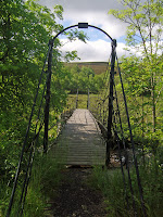
Also sadly, we now had to walk the 2 miles back towards Rattray down tarmac, but the sun was shining & there was hardly any traffic. When we got to the A93 we crossed it & noticed a sign for a footbridge. This would take us back to the other side of the Erich, & on to the path John should be coming down. According to VisitScotland it's known as the old army bridge or the Keathbank bridge, locally
Once we'd crossed the footbridge we turned left to town & came to the way-marker post where we'd begun on Monday morning. Hazel had the idea to walk back along the river & meet John, so we did, & we hadn't got far than there he was striding out towards us.

As it was still pretty early, there was time to check in & do another quick Charity Shop shop before the pre-prandial ablutions.

Dinner was at the Royal, where we were overnighting, & where they'd let John leave his car for a week while we walked. That was nice of them, wasn't it? :-)

I can't remember now what I ate. Something with meat & malt, probably?
The next morning there was no great rush to get away, so I had a look round town & tried to find a present for my cat sitter. Well, I'd hardly seen a shop for a week!

Then it was into the car & the drive back to Stirling where I caught the train to Edinburgh ~ another Reekie: this time Auld Reekie.
What happened next is in the Kiltwalk blog, so for now ~
OAO

Thursday 26 February 2015

The Cateran Trail: Day 4 ~ Kirkton of Glenisla to Alyth

Wha' da ya know?
Can you guess?
Big porridge :-D
Gordon Bennett*. It was about time.
* he was of Scottish descent
The_Glenisla_Hotel_-_geograph.org.uk_-_483827.jpg (640×480)
My room was the one under the eaves


We
 checked out fairly early, & received our daily instructions from Bob - thankfully no suggestions about a detour :-)
J & H were a bit taciturn as we set off I think there'd been 'a bit of a domestic'

Out of the hotel we walked to the right along the B951, cut through a farm & a field, & went across the cute bridge over the Isla which is pronounced Eye La.
I got this lot from a blog:

It's hard to overstate the historical significance of this bridge. 
You won't find it mentioned in the normal books on bridge engineering history, but it is almost certainly the oldest unaltered reasonably pure cable-stayed bridge in Britain, and I think it might possibly be the oldest surviving example anywhere.


From the other side the Trail went up a fairly steep hill with a cairn on top.
John was steaming ahead, so I hung back a bit & took this pic. Hazel's in blue on the L having a breather (I said it was steep!), & the hotel is the white building by the big tree. 

One of the very straight roads we did late on yesterday runs this side of the line of trees on the right (under the hill with green at the top). It was longer than it looks from here (especially after 14 miles!). The 'sheep-country' is that pale green bit above the line of trees on the left.
Occasionally people would climb the mountain and add a stone or two to the cairn at the top, if only to prove that there is nothing really damn stupid that humans won’t doTerry Pratchett, Reaper Man
While John was checking the route on his map, Hazel walked on, & it was a while before we caught up with her ~ like, lunch time!
John & I went over a wall, & left towards Whitehill Wood ~ which the trail proper skirted to the north.
As a Rule10 was required by yours truly (gotta stop having a potful of tea at breakfast when I'm walking :-@), I went in the wood (Ha ~ any excuse to walk in a wood, eh? ;-p ).
John & I met up at the opposite corner, & on going through a kissing gate & turning down hill through farmland we couldn't see any sign of Hazel below us.
We had had no signal on the mobiles while up the hill, but mine came back when walking down from the wood, & we tried calling her, but with no luck. So John called Bob & asked him to pass on a message.
Meanwhile we'd come to a farm track headed SSE, eventually came to another little wood to the right where we found these lovely guys :-)
Of course, I had to stop & say "hello".
Looking at the colouring, they were probably Clydesdales, & most looked like youngsters.


We followed that track for a fair while, probably about an hour as it continued in more or less the same direction with moor up to our right, & farmland & the Isla to our left.
We also passed a cottage with a sign advertising teas & home-made cakes, but I guess May 16th was still a bit early & there was no sign of any goodies :-( 
Shame, I was getting fed up with muesli bars!

After a bit (& with still no sign of Hazel), the road became paved, had more houses on either side, & went a bit more southerly. As we began to descend, we saw Hazel on the road below us, so marched on even quicker. Given she had stayed ahead for so long, she must have been walking quicker than she usually does?

Eventually we came to a T-junction, took the right, and then a left down past a field with a couple of nice horses in.
Very shortly we came to Hazel who had found a pile of rocks to sit on for lunch ~ it was just after 12. 
I climbed up the pile further to the south & took my long sleeves off in the sun. I was far enough away that they had a bit of P&Q for a chat.

It appeared that we would be headed uphill & off the road within a few minutes of setting off again. 
That was good. 
I wanted to feel grass under my feet as we'd had 2 hours of farm tracks & paved roads.
We walked east along the north side of a hill crowned in trees, & followed the contour round to the south, eventually crossing this bridge.
Next we went down into a field full of bullocks, across the Burn of Auchrannie & up again onto a boggy bit on a hillock. I think it wouldn't have been boggy had it not been for a leaking trough & a plethora of bullocks!

Dropping down to Adormie Farm we went left along the lane ~ more road :-( 
& passed these sheep.


As Hazel said - 

They should have gone to SpecSavers! :-)
Lord knows what the farmer was doing when he sheared this lot!

At the end of the lane ~ where it joined the B954, we went right, & after about 150 yards turned off it & went more or less due south down the Trail as it went through a field & towards a wood.
The Trail was climbing steadily, but heading towards a gap between the Alyth & Loyal hills. The gap turned out to be a lovely gulley, & as the sun had come out it was gorgeously warm in the sheltered hollow between the hills.
And there were trees :-)

I must've been on one, because I ended up at the end of the gulley track well ahead of H&J, but I set off down the metalled road towards Alyth anyway. It was straight down for just over a mile, before hitting the B952. Turning right & going towards the village & our digs, I called to tell them were I was.

Our digs in Alyth were The Old Stables, but I nipped into a cafe for a brew & a cake while I waited for the other 2.
It was still lovely & sunny, so I sat on a wall in the sun afterwards :-)

When they arrived we checked in & ordered breakfast for next day: Porridge all round. This was because Bob had told us the landlady, Eileen, made the best porridge he'd ever had, & usually had a bowl when he dropped walkers' bags off!

John fancied a beer, so we went in the Losset Inn before a walk round the village. This was cute, & I found a place where I could have a paddle in the Alyth Burn. 
Well, me & water. 
You should know by now ;-p

The Losset Inn (which was about 20 yds from the B&B) had looked good for tea, so we congregated there after a wash & brush-up. I had a 1/2 & 1/2 hawaiian & seafood pizza & an ice cream sundae to finish.

The following day's Trail was supposed to be back west to the Bridge of Cally, & then home to Blairgowrie by reversing the 1st 1/2 of Monday's walk. However, Hazel wanted to visit Fornethy House ~ where she'd stayed as a kid when she lived in Glasgow, & I didn't fancy all those bloody roads again, so we agreed John would finish the Trail (a 16 miler), & we would take the alternative 6.5 miler via Drimmie Wood after we'd been to Fornethy & Reekie Linn.

Day 4 was over & it was time for bed for H&J, but before I got there, I met the other 2 guests at the Old Stables, Scottish John & Northern Irish John. 
Isn't it odd how you can be minding your own business & quietly having a read in a comfy seat, when you get hit on by a bloke who thinks that if you're alone you must be desperate for male company.
Really!
Well, time to tell you about Day 5
OAO


Alyth is in Perth & Kinross

Wednesday 25 February 2015

The Cateran Trail: Day 3 ~ Spittal of Glenshee to Kirkton of Glenisla

Well, would ya believe it? 
No porridge. 
We're in Scotland, staying in tourist accom, & they all seem to have forgotten to get oats from Lidl, or wherever :-/ 
I said it yesterday, so excuse me for repeating myself, but,  How poo is that?
Anyway, apart from no porridge, the breakfast was edible, & after Bob had finished describing an alternative route past Loch Beanie, we were on our way.
It turned out the 2 blokes we'd trailed yesterday were called John & Bob (a different Bob, & they'd had a crap dinner, too! ), & they'd set out about 10 min before we did. 
I think they took the Loch Beanie route as we never saw them again.

Our route was round the back of the hotel & across the "Old Military Road" & Shee Water ~ which we kept down on our right for quite a while. 
For about 3/4 of an hour we walked with farmland on the right & moor on the left, & having gone behind the wall marking the edge of the farm for a Rule10, I found this.

I was well chuffed. If you click on it (apologies, focus not great :-(  ) you may be able to see it was a black ram. 
Maybe these lambs' Dad? 
The buildings of the farm they belonged to was halfway between Shee Water & the moor wall, & it was horrendously muddy. The Trail appeared to go right through the farm yard, but there was no sign of life.
There were a lot of bullocks, though, & it was probably their hoof prints that churned up the mud such a lot?
Once out of the farm yard, John started casting about for the next marker & we found it lying on its side ~ possibly having doubled as a bullock scratching post?
Hazel stuck it back upright, & off we went again.

John was quite keen to find the turn off for Loch Beanie (does it wear a hat? ;-p ), & while we wear trying to work out where we were supposed to turn left, I found this.
How cool is that?
It wouldn't fit in my day sack like the horn (which had joined the muesli bars etc.), so I hung it off the top. I felt quite Wallace ;-p
The photos were taken today (25 2 15). They've had a bit of a scrub since May 15th 2013 & now sit on my lounge shelving :-)

John tried to find the waymarker to Loch Beanie for ages, & seemed determined to go that way. I don't think Hazel was keen to turn away from the basic route, & I certainly wasn't happy just following some verbal instructions from Bob. 
Maybe another time ~ accompanied by someone who knows the way. After all, we would have been a long way from Anywhere had we got lost, & I didn't trust a route through the Highlands that wasn't obvious to follow.
Anyway, the upshot was we followed the basic route along the Shee for about 5 miles, & it was lovely walking.
John taking his ball home ;-p
I spent quite a bit of this section walking with Hazel. I got the impression we had spoiled John's fun a bit. Ah well. C'est la vie!

The Trail eventually came out on an unmetalled road leading up to the back entrance to Dalnaglar Castle. 

There was big wall in the way, but being the monkey I am (according to the Chinese zodiac, & my penchant for climbing things), I got up high enough to take this pic.
Apparently it's a retreat for some family or other, but you can hire the place! I note the website says 'Prices on request'. 
In other words, if you have to ask, you can't afford it ;-p
My notes are a bit garbled, so I surfed a bit to check the name, & came across this pic of the castle in the snow. It looks like that photographer was a monkey, too :-)
Dalnaglar Castle, Glen Shee

With the castle to our right, the track curved round to the left & up through some woods belonging to the castle. We knew this because there were signs warning peeps not to go in as there was a danger of being shot! 
Um %-\

We then hit a small country lane, &, at a 3-way junction on the B951, found some logs & stones to sit on for lunch. There was a handy little wood for a Rule10 as well.
Too much information? ;-p
It had been pretty sunny & warm so far, but started to spit as we were finishing up, so Hazel became a crow again!
The Cateran Trail bumf says the next part of the trail "followed quiet minor roads" & takes you past Forter Castle.
God it was boring :-(
It doesn't sound far, but 2.5 miles on a tiny tarmac road, dodging traffic was crap. The best bit was eventually (after a couple of miles) catching sight of Forter Castle in the distance and getting closer, little by little.
A 1/4 of a mile west of Forter, the B951 curved right, but we headed down the lane to the village, & discovered a renovated keep in the valley.
The main entrance
Arty-farty castle & tree pic
This is what the web says about Forter Castle:

Forter Castle

Forter CastleThis is a story of a bloody feud…and some prodigious walking.
Forter Castle is a 16th century keep, originally owned by the Ogilvies, one of the oldest families in Angus. The chief of the family was created Earl of Airlie in 1639 by Charles 1, and a year later he was away fighting for Charles in England when the Campbells of Argyll took their chance to further a long-running feud between the clans.
The story goes that the Campbell raiding party took just two days to cross from Inverary! The Earl’s wife was heavily pregnant at the time and living at Forter Castle, but she got enough warning from her eldest son to escape and walked over to Dundee with the younger children, where she gave birth to a baby girl.
The Campbells passed a leisurely two weeks burning and looting the Ogilvy estates. So much so, that it was said at the time the Earl of Airlie was ‘left not in all his lands a cock to craw day.’ On their way out of the glen they burned Forter Castle and it remained a blackened shell until was restored in the mid 1990s.
NB: Inveraray to Forter is about 100 miles using the current A roads, but I guess the Campbells would have gone across country. Nifty going in 2 days!
Forter to Dundee is 30 miles. Not bad going for a pregnant lady, & without the mod-cons of today's walkers like specialist boots, Gore Tex, etc.
The Cateran bumf suggests the "more energetic walkers" may wish to take the alternative route into Glenisla by crossing Mount Blair. It says "the summit offers panoramic views of the surrounding countryside and on a clear day you may even spot Ben Nevis in the distance." 
Well, we'd been able to see Mt Blair more or less all day. It's dead easy to spot ~ there's a telecoms mast on top!
After the castle, the road curved left through the village (a hamlet, really ~ no shop, pub or church), & then down & right ~ onto a road leading to Kirkton of Glenisla. A signpost by a Cateran Trail waymarker said it was 4 miles away along the lane, but we climbed over a stile & cut back on ourselves as we climbed over 100m along a track which took us up above Auchintaple Loch. By going this way we would end up doing 6 miles not 4, but at least it was off the tarmac :-)
The river Isla from the track up to Auchintaple Loch
I have to admit that initially I wasn't much chuffed having to walk Away from our destination for an hour, but it was nice once we got up there ~ & turned in the right direction again. My built-in compass had been having a right moan about walking north-east instead of south east!
John, Hazel & Auchintaple Loch


Once up top, there was short stretch above the loch, & then a marker showed we had to branch right & go down to the woods ~ the ones above John's head in the pic.
Ah. Woods :-)  
It was great in there. All dark green & peaceful. Awesome.
Even if the was a man lurking behind a rock ??
Shame it was less than a mile before we came out again. 
Shortly after we left the nameless wood, we branched left to climb above the loch behind us, and eventually ended up crossing a Really boggy bit. We could see the waymarker a little way ahead on (dry) moorland, but we had to negotiate a fair stretch of bog to get there. I stuck to the fence. I figured, if fence posts would stay in, it must be more stable there than the rest of it.
It was pretty hard going for well over 1/2 an hr., but once higher up, the going was easier. 
After that the trail stayed quite high, & we passed Loch Shanda on our left. Sorry, no pic.
Loch Shanda behind us, we took a right fork & walked across a high bleak bit of farm land (sheep country?), for a mile or so before walking down 2 sections of Very straight track down towards our old friend, the B951.
The high sheep-country, John, & a waymarker


Once there we turned to our right (WSW) & had our final few minutes' walk back along the road we'd 1st walked on 9K (& about 5 hours) previously.


Our hotel was named after the glen, & was clearly a 'walkers with money' place. 


It was quite pricey, but the fire was hot & the food was good.

John never made dinner, & Hazel came down a while after me.
So, I ate my garlic bread & brie on my ownsome, sitting with my back to the fire in the chair by the 2 guns.
Garlic bread & brie for tea. The malt's off-shot to the right!


My room was a west facing single, en-suite, & I spent a fair while in the power shower sorting out the bits that had worked hard that day.
Plus, with 11 miles to Alyth, I was hoping there'd be porridge to start me off ;-q
OAO

Tuesday 24 February 2015

The Cateran Trail: Day 2 ~ Kirkmichael to Spittal of Glenshee

I asked for porridge.
There wasn't any: How poo is that?


The Pine Tree Lodge Breakfast View
It didn't really make up for there being no porridge :-(


At least the view from the breakfast table was nice :-)
Today's leg was only 8.5 miles, & the 1st bit (once we were out of Kirkmichael) was through some awesome woods.
I love walking in woods :-D
Hazel in Kindrogan Wood
We came out of the woods going downhill & passed this lovely house.
What a great place to live!
Next up was Enochdu.
The Cateran Trail bumf says this means Black (that's the Dhu bit) Meadow or Moor.
It's a tiny place where the Cateran Trail crosses the A924, & then heads up to the edge of the Dirnanean Estate, through Calamanach Wood & up over to Spittal.

But I'm getting ahead.

Having crossed the road, we moseyed onwards & upwards ~ in the bloody rain again :-(, curved R then L through the (very smelly) Dirnanean Home Farm, & continued upwards & onwards.

This is a pic of a couple of rocks at the Enochdhu side of Home Farm that looked like a tortoise.
It did!
Honest!

Then we left the farmland behind & walked quite a way through Calamanach Wood ~ mostly conifers, before hitting open moorland.
In the wood there were a lot of hides: presumably where peeps who shot things hid.
John & I had a pee in one*, but don't tell anyone.
* Not at the same time!


John's Rule10 Hide is just out of shot to the L
There were also a couple of guys ahead of us we'd been seeing at various distances all morning. More of them later.

As usual, I was walking more quickly, so I kept stopping in the wood to look & listen, & I caught a few glimpses of wildlife. No golden eagles, sadly, but deer, various birds, & a stoat.
Once out of Calamanach Wood the moorland felt really remote, &, as the rain had stopped, I didn't need to keep my head down & so could look about.

John walks ahead


While I was on my own I had a sing.
Maybe that's what brought the rain on again? ;-p

After a bit I held back for Hazel, & John walked ahead.
The trail is that green bit on the left, just above 1/2 way up the pic above


John walks even further ahead


You can see the green of the trail meandering like an eel up towards the lump & slightly L of centre.


This was a nice little linn & I refilled my water bottle.


It was in the little pool next to that clump of heather on the L. I think H&J thought I was bonkers, but that's nothing new!

Shortly after that we reached the Upper Lunch Hut and had lunch there. 
Allegedly, in 1865, Queen Victoria did as well.

The 2 blokes had got there before us & we had a little chat with them. John discussed routes, & it was a bit like, "You show me your map, & I'll show you mine" ;-p

Then it started to rain again & we went inside.
The blokes left anyway, but we decided to wait a bit. 
It wasn't like we had miles to go today.

And it did stop, so off we went,
Happily, after all this time blogging, I've just discovered how to make the pics bigger! Now you can see the roof of the Upper Lunch Hut about level with Hazel's head by an S-shaped green bit. 
Click on it & it'll get even bigger.
Ain't teknologgy wunnerful :-)
 
It wasn't long before the rain began again, though :-(


& it rained all the way up to the highest point of the trail at the Lairig Gate at 2130'.


There's a pic of the gate below, but meanwhile, here are some views of John, Hazel & the moor in the rain!

That's John. I don't know where Hazel was?
Cateran Trail Marker
The one we were following was on the other side & pointed up the hill to the gate.
Like this one
Hazel the crow!
Well, it kept her dry :-)

Top of the shop - The Lairig Gate. But I guess you knew that already?


Our 1st view of Spittal of Glenshee, & our overnight resting place
Once over the top, it was downhill all the way to Spittal. 
According to the Cateran Trail bumf (again), Spittal is old Scots for 'refuge on a remote hill pass', & was created when wolves still roamed the highlands.


The valley in the sunlight off to the left is Glenshee, where there is a little ski resort. It's quite good fun, & although the runs are short compared to the Alps, there's some good gulleys.
I got engaged there in Feb 94 ~ the the top of the Cairnwell Chair in a blizzard!
Qué romántico ;-)
It was very boggy on the way down, & even the tussocks sank into the mud :-/

I obviously thought this moss-covered rock looked like something at the time. It may have been a fish?

I get notions like that! ;-p
It's not as obvious as the tortoise at Home Farm, but it does look a bit like a fish.
One of those ones in Stingray, anyway ;-p


We're nearly at the bottom here, so John took a couple of me crossing a burn.


That's the ski-suit that stopped my bum getting wet on Strathardle.

This little burn, & it's very late trees, looked better in real life.
We had walked down from the top.


This is about a hundred metres above the little pool where I went for a bathe once we'd checked in.
I think J&H had a kip, but as it was sunny & quite warm, I donned the bikini, went across the A93, & bathed my bod in the burn.
It did take quite a few min to get the whole body submerged (it was frikkin' cold), but my feet loved it.
As we had 14.5 miles to walk the next day, I was treating my feet with a bit of TLC ~ well, kinda ;-p

Once back in my room it was still only about 4 ~ we'd got down just after 1/2 past 2, so I went to bed till dinner time.
Boy, was I looking forward to dinner after 2 days on muesli bars, hi-energy bars, & NO PORRIDGE.


Desafortunadamente, there was chef trouble again, & 2 teenagers had been left to feed the guests.
We'd all ordered burgers & chips.
The burgers were all raw in the middle, & the chips were mostly still partially frozen.
We told the lads, & they explained being left in the lurch to do dinner for about 12 guests. 
We were stuck - there wasn't even a shop at Spittal, never mind somewhere else to eat, so we told them to take the burgers away, & thought we'd try the pizza.

Mmmm. Not a cunning plan, Baldrick, but between the edges of the burgers, the 'not quite as frozen as the others' chips, & a partially edible pizza, we were fed ~ kinda!

We had a long walk to Kirkton of Glenisla the next day, so just had one drink (on the house obviously!) before bed.

At least there was porridge to look forward to in the morning :-q

OAO