Gwen knocked shortly after 0700 & we walked down the road out to the lake in time for the sunrise.
Gwen looked after someone's garden which looked out over the lake, so we walked across it to get views of the dawn sun.
 |
| Lake Tarawera at 0722, 16 3 16 |
 |
| 1 minute later |
 |
| Awaiting breakfast? |
 |
| Someone's rod at 0725 |
 |
| Breakfast at the Barmy Bellbird: toast, cream cheese, eggs from Gwen's hens, blueberry jam, fruit tea, & coffee. Yum :-) |
Back at the house, we had a leisurley breakfast shortly after half past 7, & I was packed & ready to go before 0900, but grabbed a couple of
 |
| Bush next to Barmy Bellbird |
Mario had already left for his job doing some tree prunung or something, but I told Gwen I'd love to return for more than 1 night.
Ahem ;-p Maybe next time?
Gwen was off to do her Wednesday 3hr gardening duty, but I followed her car down to a track for a brief walk.
I had nearly 200K to go before my next stop on the shores of Lake Waikaremoana, & I hadn't put bug spray on or boots, so I only had a 5 minute trek through the trees.
However, I did drive to the end of Spencer Rd & wrote up some notes in the silence before turning round & briefly stopping at a lakeside reserve.
It was fairly rocky, but I spent about 10 minutes splashing around & clicking.
The SH38 was actually a great drive :-))
Initially, it was long straights between plantations & later it wiggled along valleys through the bush for ages.
A road for a tree lover like me :-D
Just before midday & before I reached Murupara I got my 1st bit of gravel, & decided to see how long the stretches were.
Over the next 3 hours I kept scribbling the mileage on my notes everytime I hit & left gravelly bits.
I just checked my notes, & the longest section was 34.4K!
But I'm ahead of myself again ;-)
it was very cute, so another stop for pics occurred, & had I not been in a bit of a rush (the gravel had severly restricted my speed),
I would probably have risked a dip.
It was hard-top over bridges & through the very occasional hamlets like Te Waiiti, but these were all so small, Gmaps has no idea where they are!
Once the inlet was behind me I got my first sight of the water through the trees.
Very shortly after I came across the Mokau Falls, tumbling & thundering into an inlet, aptly named Mokau Inlet.
It's about 1/2 way between the Hopuruahine Inlet and Te Urewera.
I took the first two pics from the road at the other side of the inlet to where
As you can see from the photo, it was raining pretty hard, so I swapped my shorts for trackie bottoms & put a sweatshirt & a hoody on to save on weight.
Ahem ;-p Maybe next time?
 |
| Ready for the off at 1 minute to 9 |
 |
| The track through the bush Gwen had pointed out |
 |
| My kind of track :-D |
Gwen was off to do her Wednesday 3hr gardening duty, but I followed her car down to a track for a brief walk.
I had nearly 200K to go before my next stop on the shores of Lake Waikaremoana, & I hadn't put bug spray on or boots, so I only had a 5 minute trek through the trees.
However, I did drive to the end of Spencer Rd & wrote up some notes in the silence before turning round & briefly stopping at a lakeside reserve.
 |
| The Barmy Bellbird is about 1/2 way along the left (west) of the lake |
 |
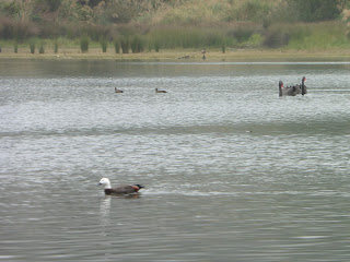
| Duck at Stoney Point Reserve She let me get pretty close! |
Back in the car at 0925, & with AM still on the radio, Tarawera Rd took me past the village, Te Wairoa, which had been buried by the eruption of Mt Tarawera in 1886.
As usual, Google provided further info., this time from the Rotoroa Travel Secrets website:
The Buried Village of Te Wairoa, as an attraction in Rotorua, is New Zealand’s mini version of Pompeii, you know, the Roman city buried when Mt Vesuvius erupted. Mt Tarawera? Is our volcano. Te Wairoa itself would have to be the birthplace of tourism in New Zealand. Wealthy visitors would come from all around the world to see, photograph, paint, sketch and bathe in the mineral waters at the nearby famous Pink and White Terraces, touted at the time as being the eighth wonder of the world. I really have to give it to the travellers back in those days.Imagine travelling across the ocean for 4mths, arrive in Auckland then having to boat/coach to get to Rotorua followed by a buggy to Te Wairoa before getting onto a whaleboat to cross Lake Tarawera to get to the terraces on Lake Rotomahana. Phew. And we think we are intrepid huh? And can you imagine the clothes they would have been wearing. Crinoline dresses, corsets, dainty high-heeled lace-ups and the requisite hat for the ladies; bowler hats and starched shirts for the men. It must have been so uncomfortable; they would have loved our gear now. Because of these visitors, Te Wairoa became a bustling village boasting a population of about 150, two hotels, a hall, stores, the Hinemihi meeting house, a church and school as well as both European and Māori houses . The Tuhourangi people, a sub-tribe of Te Arawa, owned most of the land in the Te Wairoa area which also expanded out to include the terraces. With astute leadership, they cashed in big-time on the lucrative tourist trade. Cultural performances, carriage across the lake, food-stops on the way, the taking of photographs, paintings etc. all attracted charges. Visitors needed to be wealthy. Members of the tribe could earn up to ₤4,000 annually, that was a huge amount in those days. But, there always seems to be a downside. Problems began to creep in. Alcohol abuse, prostitution, illnesses they had no immunity against, crops not attended to. It's said that Mt Tarawera erupting was payback for the tribe leaving behind the old ways. What a retribution. Over 120 people were wiped out and Te Wairoa was decimated.Just
A little further on were 2 famous lakes, Blue & Green AKA Tikitapu & Rotokakahi.
As this may be my last chance to see them, I stopped for quick pics, but sadly they weren't being particularly blue & green that morning.
Rotokakahi was 1st & is quite a bit bigger than the blue Tikitapu.
Just off the road was a little raised viewpoint between the two, so I pulled off for some pics & found some useful info-boards.
As usual, Google provided further info., this time from the Rotoroa Travel Secrets website:
The Buried Village of Te Wairoa, as an attraction in Rotorua, is New Zealand’s mini version of Pompeii, you know, the Roman city buried when Mt Vesuvius erupted. Mt Tarawera? Is our volcano. Te Wairoa itself would have to be the birthplace of tourism in New Zealand. Wealthy visitors would come from all around the world to see, photograph, paint, sketch and bathe in the mineral waters at the nearby famous Pink and White Terraces, touted at the time as being the eighth wonder of the world. I really have to give it to the travellers back in those days.Imagine travelling across the ocean for 4mths, arrive in Auckland then having to boat/coach to get to Rotorua followed by a buggy to Te Wairoa before getting onto a whaleboat to cross Lake Tarawera to get to the terraces on Lake Rotomahana. Phew. And we think we are intrepid huh? And can you imagine the clothes they would have been wearing. Crinoline dresses, corsets, dainty high-heeled lace-ups and the requisite hat for the ladies; bowler hats and starched shirts for the men. It must have been so uncomfortable; they would have loved our gear now. Because of these visitors, Te Wairoa became a bustling village boasting a population of about 150, two hotels, a hall, stores, the Hinemihi meeting house, a church and school as well as both European and Māori houses . The Tuhourangi people, a sub-tribe of Te Arawa, owned most of the land in the Te Wairoa area which also expanded out to include the terraces. With astute leadership, they cashed in big-time on the lucrative tourist trade. Cultural performances, carriage across the lake, food-stops on the way, the taking of photographs, paintings etc. all attracted charges. Visitors needed to be wealthy. Members of the tribe could earn up to ₤4,000 annually, that was a huge amount in those days. But, there always seems to be a downside. Problems began to creep in. Alcohol abuse, prostitution, illnesses they had no immunity against, crops not attended to. It's said that Mt Tarawera erupting was payback for the tribe leaving behind the old ways. What a retribution. Over 120 people were wiped out and Te Wairoa was decimated.Just
 |
| Rotokakahi from the road |
As this may be my last chance to see them, I stopped for quick pics, but sadly they weren't being particularly blue & green that morning.
Rotokakahi was 1st & is quite a bit bigger than the blue Tikitapu.
 |
| Taken from the little viewpoint between the lakes |
 |
| Ditto |
 |
| There were a couple of info boards at the viewpoint . . . |
 |
| so I got pics to save me writing it down |
 |
| & Ditto |
 |
| I was allowed a paddle, so had one & took this while so doing! |
There were 2 families in campers getting ready to tramp.
It would have been nice to take a walk, but I had several hours driving ahead along the SH38 which wiggled its way towards the east coast, so I couldn't.
Another 'maybe next time'?
Back in the car I drove to the top end of Tikitapu & parked up on the green sward.
I'd decided a paddle was in order.
Lake Tikitapu was clearly used for water sports, so I walked back a little way & got my feet (& sandals) wet.
 |
| I'd parked up at the top end & walked back for a paddle |
It was fairly rocky, but I spent about 10 minutes splashing around & clicking.
 |
| My shadow in the water |
 |
| Tikitapu looked a lot bluer in the sunshine :-) |
 |
| View across Tikitapu from where I was stood in the water |
It had been a bit overcast, but happily, while I was in the water, the sun came out & Tikitapu did what it said on the tin (that's an English joke about an advert for Ronseal-Google it if you've not seen it on UK TV ;-p ).
The sun put a glint on the water & the blue matched the sky.
It was great :-D
My sandals just about survived the soaking, & I kept them on my feet so they'd dry in the footwell when I got back in the car.
Then I headed to the SH30 at the SE end of Lake Rotoroa.
Then I headed to the SH30 at the SE end of Lake Rotoroa.
 |
| View along western edge near the car |
I wasn't on it long before it turned left off the Rotoroa ring-road at a
sign for Taupo & Te Kuiti.
sign for Taupo & Te Kuiti.
Um?! I didn't want to go either!
They were completely in the wrong direction! ! !
I followed the SH30 for about 12K until it became the SH5 headed about SE.
The SH5 would eventually get to Taupo & its huge lake, but I was only on it for about 20K when the SH5 went off
 |
| At about 1130, I was on a 7K straight on the SH38 headed for Tuai |
right & I carried on along the SH38.
The Bay of Plenty region had turned into the Waikato at Tumunui, & the SH38 crossed the line a couple more times before staying in the Bay of Plenty until just north of Waikaremoana.
The Bay of Plenty region had turned into the Waikato at Tumunui, & the SH38 crossed the line a couple more times before staying in the Bay of Plenty until just north of Waikaremoana.
It felt very remote out there.
But I'm ahead of myself.
 |
| Not sure if I was moving at this point . . . |
The SH38 was actually a great drive :-))
Initially, it was long straights between plantations & later it wiggled along valleys through the bush for ages.
A road for a tree lover like me :-D
 |
| But I was here when the SH38 became much more 'rural'! |
 |
| A lonely road through the bush |
 |
| I'd stopped & walked back for this one |
 |
| The SH38 wound through the valleys . . . |
Over the next 3 hours I kept scribbling the mileage on my notes everytime I hit & left gravelly bits.
I just checked my notes, & the longest section was 34.4K!
But I'm ahead of myself again ;-)
 |
| & the deepest bush |
 |
| A little herd of horses . . . |
At about 1220 I saw these guys having a brunchy lunch.
Of course, another pic-stop was called for :-)
 |
| wandering all over the road . . . |
I tried to say Hello properly, but they weren't for letting me anywhere near a stroke.
 |
| & pretty enough to stop for a pic |
 |
| One of the waterfalls . . . |
I had to make do with photos.
 |
| & another closer up One may be the Totarapapa falls? |
The NZ Topo map shows loads & loads of waterways around the SH38, but they were mostly too small to show up on Gmaps. Only the Whakatane River just before Ruatahuna was named on there.
However, the Topo map helpfully showed the Totarapapa Falls were on my right, so maybe one of these pics its it?
The Topo map also told me the stream the road had followed was the Mangapae - at least a lot of it was.
Whatever it was called,
The Topo map also told me the stream the road had followed was the Mangapae - at least a lot of it was.
Whatever it was called,
 |
| The SH38 followed the Mangapae Stream for quite a while |
 |
| The Mangapae & my car looking tiny in the trees |
 |
| If had been sunnier, I'd've been in it! |
 |
| Somewhere near Ruatahuna, I think |
 |
| Nice tree, but I have no idea why I took it? Possibly the colours & the umbrella shape? |
The gravel stopped on the approach to Ruatahuna: it was about 1300 by this time.
The Whakatane river began near Ruatahuna in the Urewera National Park & flowed north for about 60 miles to the coast at Whakatane. I'd seen the estuary, so I like that I nearly saw the source as well :-D
Nearing Ruatahuna I kept seeing a small plane above me, so when I stopped for a pic of a nice tree by the roadside, I looked skywards.
Annoyingly, it kept vanishing into the valleys & behind the higher trees in the bush.
Nearing Ruatahuna I kept seeing a small plane above me, so when I stopped for a pic of a nice tree by the roadside, I looked skywards.
Annoyingly, it kept vanishing into the valleys & behind the higher trees in the bush.
 |
| I kept hearing it, but took ages staring up into the clouds before managing a pic |
I eventually managed one just in time.
It vanished for good shortly after.
Leaving Ruatahuna behind, the road reverted to gravel for most of the rest of the wat to Te Urewera.
It vanished for good shortly after.
Leaving Ruatahuna behind, the road reverted to gravel for most of the rest of the wat to Te Urewera.
 |
| A mini-volcano covered in bush |
 |
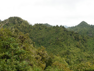
| As with previous excursions along roads through the bush, the topography was interesting & showed NZ's volcanic history |
The views either side varied from dense bush to the occasional view of a little pointy hill in the distance.
I eventually found a suitable place to pull over for a pic or 2.
 |
| This is the previous pic minus the zoom |
According to both maps, the Hopuruahine Stream ran along the side of SH38 as it neared the lake on its way south.
However, it was virtually invisible due to the continuing dense bush.
Happily, though, there were occasional views of the egg-box topography & I stopped where I could for some more pics.
 |
| I couldn't resist stopping for another pointy peak |
After a bit, the SH38 crossed the Hopuruahine Stream over a bridge of the same name, leaving it to the right ~ albeit still hidden by bush, & a bit further on the stream entered a valley & then the lake at the Hopuruahine Inlet, the most northerly part of Waikaremoana.
 |
| Another eggbox-country pic |
 |
| My 1st pic of Waikaremoana at about 1415. It means The Sea Of Rippling Waters in Maori |
Once the inlet was behind me I got my first sight of the water through the trees.
It was about another mile though before I found a place to stop for the celebratory photo.
I just spent ages on Gmaps Street View looking for this shot & I found it ~ eventually.
It's things
 |
| Looking south a couple of minutes later |
like that which mean I take so long producing each blog!
Ooops ;-p
If you go on Gmaps, the camera car was filming on a lovely sunny day, & Waikaremoana is lovely & blue in the sunshine :-)
On this day, though, it was still overcast & weirdly eerie.
I'd been alone on the road for hours!
I'd been alone on the road for hours!
 |
| The clouds lower over Waikaremoana |
Very shortly after I came across the Mokau Falls, tumbling & thundering into an inlet, aptly named Mokau Inlet.
It's about 1/2 way between the Hopuruahine Inlet and Te Urewera.
I took the first two pics from the road at the other side of the inlet to where

the river fell in.
You can see the white line of the bridge above the falls on this pic.
You can see the white line of the bridge above the falls on this pic.

Then driving round & over the bridge above the falls, got out for the third one.
 |
| The top of the falls from the bridge over the Mokau Stream |
Back in the car, & 20 minutes on, I came to Te Urewera.
It was time for pit-stop: I'd been driving for nearly 6 hours & it was 10 to 3.
I'd done 183k at this point, which ~ with the gravel & the photo stops works out at about 30kph.
I'd done 183k at this point, which ~ with the gravel & the photo stops works out at about 30kph.
 |
| I got this at my Waikaremoana Holiday Park brew stop |
 |
| An up-ending duck Or maybe a goose? |
1st job was a rule 10, then a coffee.
While they brewed up I had a look round the on-site gift shop & found a gorgeous black T-shirt with a DOC NZ '9 Great Walks' design on the front in various greens with NZ flora & fauna picked out in other colours.
While they brewed up I had a look round the on-site gift shop & found a gorgeous black T-shirt with a DOC NZ '9 Great Walks' design on the front in various greens with NZ flora & fauna picked out in other colours.
It's one of my favourite-ever Ts :-D.
Post coffee I stretched my legs & had a wander down to the slipway.
There were quite a few boats moored out on the
lake, & 2 or 3 moored on the water's edge, but it was drizzling so I didn't hang about out of doors.
Post coffee I stretched my legs & had a wander down to the slipway.
There were quite a few boats moored out on the
 |
| Paradise duck on Waikaremoana |
 |
| My bed for the night at Big Bush lodge |
20 min later I was at Tuai where I was booked in at Big Bush Holiday Camp.
As the crow flies (from Onepoto Bay at the SE corner of the lake), Big Bush is less than
 |
| The view out of the window ~ Te Whakatutu |
3K from Waikaremoana, but the road between is 1/2 as much again due to it wiggling past little lakes & not so little hills.
I had a choice of room in the chalet as I was the 1st of the night's guests to arrive just before 4pm.
I chose a double with a view out to the little lake, Te Whakatutu.
Then I went out for another wet wander before going online in the bar for a bit to check Es
 |
| A wet afternoon. It's what keeps it so green & lush |
& have a warm brew: hot chocolate this time.
I decided to make tea early-ish, & borrowed some salt from the bar/restaurant.
On the way back, I got a few more pics of the
damp day while it was still light. We were in a valley, so sunset would be earlier.
When I got back to the cabin I found 2 other singles had arrived, & then 3 Kiwi ladies turned up. The 3 of them were starting out on the Waikaremoana Great Walk the next morning & were carrying everything with them for 4 days. Their backpacks were huge. Phew!
From what I can gather from Google, the walk doesn't go all the way round, but is a 44K walk along the southern & western edge of the lake, & this is what the DOC blurb said:
According to Wiki:
A taonga is now a treasure in Māori culture; it can be anything from a word to a memory. The current definition differs from the historical definition, noted by Hongi Hika as "property procured by the spear" [one could understand this as war booty or defended property]. Tangible examples are all sorts of heirlooms and artefacts, land, fisheries, natural resources such as geothermal springs and access to natural resources, riparian water rights and access to the riparian zone of rivers or streams. Intangible examples may include language and spiritual beliefs.
 |
| The damp patio. No al fresco eating today! |
I decided to make tea early-ish, & borrowed some salt from the bar/restaurant.
On the way back, I got a few more pics of the
 |
| The eaves over my window |
When I got back to the cabin I found 2 other singles had arrived, & then 3 Kiwi ladies turned up. The 3 of them were starting out on the Waikaremoana Great Walk the next morning & were carrying everything with them for 4 days. Their backpacks were huge. Phew!
 |
| My window is the 1st on the left |
 |
| Inside the bar/restaurant |
Lake Waikaremoana can be walked either from Onepoto in the south or Hopuruahine in the north. It's not a circuit track and is described here from Onepoto. For a 3 night / 4 day trip: Day 1 - Onepoto to Panekire Hut; Day 2 - Panekire Hut to Waiopaoa Hut; Day 3 - Waiopaoa Hut to Marauiti Hut; Day 4 - Marauiti Hut to Hopuruahine.
So, as I had driven from Hopuruhine to Onepoto, the walk went round the rest of the lake.
Because I would be flying out to Auckland from Napier & then home via Dubai the next day, I was having porridge for tea & breakfast (hence the salt ;-p). The tomatoes from the Pac'n'Save in Rotoroa got eaten as well, plus some nuts, a peach & a plum. Then I made a brew from the rest of the kawa kawa leaves I'd got from Kapiti Island, & finished off with a coffee courtesy of Big Bush.
A bit eclectic, but I wanted to get rid of as much as possible before the flight from Napier so I wan't above 7Kg for my AirNZ carry-on.
There was no light bulb in the lounge light, so we all squashed into the kitchen where I discovered the 3 Kiwis were Sheena, Catherine & Katrina, & the (unmamed!) single Norwegian girl was also doing the walk. The single bloke was either in the bar or in bed!
It did get dark by 8, so I went to bed with sudoku & caught up with the day's notes.
March 17th: Big Bush to Napier & onwards
Next morning I was due to catch a flight at Napier Airport at 1435 (>160K away), & had to take the car back 1st. Given the likelihood of slow-going gravel, I'd asked at the Big Bush bar & they suggested I set off before 0730. Waking before 7, I finished off the porridge, had another couple of free coffees & set off with 133093 on the clock. Shortly after I'd left the village I was back to driving on gravel, & it was like that for quite a lot of the 50K along the SH38 to Wairoa where it joined the SH2 I'd driven north on the week before.
I had a brew, loo & petrol stop at Wairoa (my notes say there was a very cheery girl at the petrol station :-D ), then continued south along the SH2 at 0850, stopping 40 minutes later for a couple of pics of the Mohaka Viaduct. Wiki says the Mohaka River is 172K long & a Maori taonga: ie, something that is highly prized. According to Wiki:
A taonga is now a treasure in Māori culture; it can be anything from a word to a memory. The current definition differs from the historical definition, noted by Hongi Hika as "property procured by the spear" [one could understand this as war booty or defended property]. Tangible examples are all sorts of heirlooms and artefacts, land, fisheries, natural resources such as geothermal springs and access to natural resources, riparian water rights and access to the riparian zone of rivers or streams. Intangible examples may include language and spiritual beliefs.
 |
| 'nuff said |
 |
| The Mohaka Viaduct |
The airport was another 73K from Mohaka, & I had to find the depot & give the car back.
I reached the Pegsus depot on Taradale Rd by 1110 ~ in plenty of time for check-in by 1400. I'd done 203K that morning.
Once they'd given the car a once over, I was driven to the airport & when I took my ruckie out of the boot, I showed the bloke my wonderful mere
He explained that they were normally bestowed rather than bought, but said I could bestow it on my house. So I have.
That said, I will have to bestow it on my new house whenever I move to Scotland.
 |
| A wet apron at Napier Airport |
The Tikitapu had killed the sandals, & I'd left them in the bin at Big Bush, so that was a bit less to offset the weight of the mere & the various presents I'd bought for my lovely cat-sitters.
A few coffees, a butty & a last glass of Hawkes Bay vino later, they called my flight & off I went to Auckland, managing an aerial pic of the Hawkes Bay countryside once we were airborne.
We landed on time at 20 to 3 & I remember it was sunny in Auckland when I walked from the Domestic to the International terminal.
I also remember doing a troll round the Duty-Free & checking out the cheapest prices for food & drink. I had a bit of cash left, but not much, having paid Amoe at Big Bush in NZ$ the day before.
I had ages to wait: my check-in was at 1930 & my direct flight to Dubai 2 hours later.
No Australian stopover this time, & the length of the flight was exceedingly dehydrating. I remember asking for water loads of times during the night: my eyes were so dry it felt like I had pins sticking in them :-(
I think I won't do that route again!
I thought I'd made notes about the rest of the trip, but I'm dammed if I can find them, 3 years on, so this will have to be it for NZ16.
See you all on the Bessie Ellen for my Hebrides jolly of July 2017.
Don't hold your breath, though. To paraphrase Lawrence Oates (again), I may be some time!
OAO
 |
| Just after take-off from Napier |
We landed on time at 20 to 3 & I remember it was sunny in Auckland when I walked from the Domestic to the International terminal.
I also remember doing a troll round the Duty-Free & checking out the cheapest prices for food & drink. I had a bit of cash left, but not much, having paid Amoe at Big Bush in NZ$ the day before.
I had ages to wait: my check-in was at 1930 & my direct flight to Dubai 2 hours later.
No Australian stopover this time, & the length of the flight was exceedingly dehydrating. I remember asking for water loads of times during the night: my eyes were so dry it felt like I had pins sticking in them :-(
I think I won't do that route again!
I thought I'd made notes about the rest of the trip, but I'm dammed if I can find them, 3 years on, so this will have to be it for NZ16.
See you all on the Bessie Ellen for my Hebrides jolly of July 2017.
Don't hold your breath, though. To paraphrase Lawrence Oates (again), I may be some time!
OAO