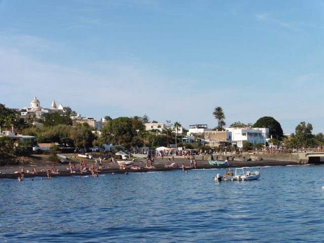
After sailing in the dark for the 1st time, the next morning we were anchored off Panarea when we woke.
I actually woke quite late at 0815, & my notes tell me I had 5 cups of coffee & 5x bread & honey for breakfast!
Must've been all that walking last evening ;-)
 |
| Aline checks out Rahul's fishing line |
After breakfast, it wasn't long before we boarded the zodiac for the shore & our trip to the prehistoric village on the Capo Milazzese.
 |
| Rahul drives us to shore |
We were to walk there from San Pietro, & Gmaps reckons it's about 2.5K.
Before we set off on our walk, Nic said
we could get Granita
from the Bar Da Carola on the prom. So we all piled in there & found it had a very impressive selection ~ over 30 different flavours of Granita to choose from!
from the Bar Da Carola on the prom. So we all piled in there & found it had a very impressive selection ~ over 30 different flavours of Granita to choose from!
It took a while before we all decided what flavours we wanted & were served ;-p
I had a Prickly Pear one. It was very nice, but chocolate is better ;-q.
I got this from Wiki about Granita:
Granita or Granita Siciliana is a semi-frozendessert made from sugar, water and various flavourings. Orginally from Sicily, it is available throughout Italy in varying forms. It is related to sorbet & Italian ice; however, in most of Sicily, it has a coarser, more crystalline texture. Although its texture varies from coarse to smooth, it is always different
 |
| Peaceful San Pietro in the morning |
 |
| A San Pietro street with random peeps on it |
 |
| San Pietro houses were generally very floral :-) |
from that of ice cream, which is creamier, and from that of sorbet, which is more compact; this makes granita distinct and unique.
We walked along the prom for a bit (sucking our juicy & cool Granitas), & then went right up the Vette Panarea. This took us up past a bakery which smelled wonderful & made me feel hungry, depite all the bread & honey at breakfast.
According to the Sicily Visitor website:
Panarea is a holiday home to many of the aristocratic families of Italy and Europe and draws in the jet set and Hollywood filmstars including Kate Moss and Urma Thurman.
I think they mean Uma ;-)
 |
| Wonderfully curved olive tree trunk |
We walked along the prom for a bit (sucking our juicy & cool Granitas), & then went right up the Vette Panarea. This took us up past a bakery which smelled wonderful & made me feel hungry, depite all the bread & honey at breakfast.
According to the Sicily Visitor website:
Panarea is a holiday home to many of the aristocratic families of Italy and Europe and draws in the jet set and Hollywood filmstars including Kate Moss and Urma Thurman.
 |
| Holiday homes of the rich & famous? |
 |
| The Pallas is one of the craft anchored out there |
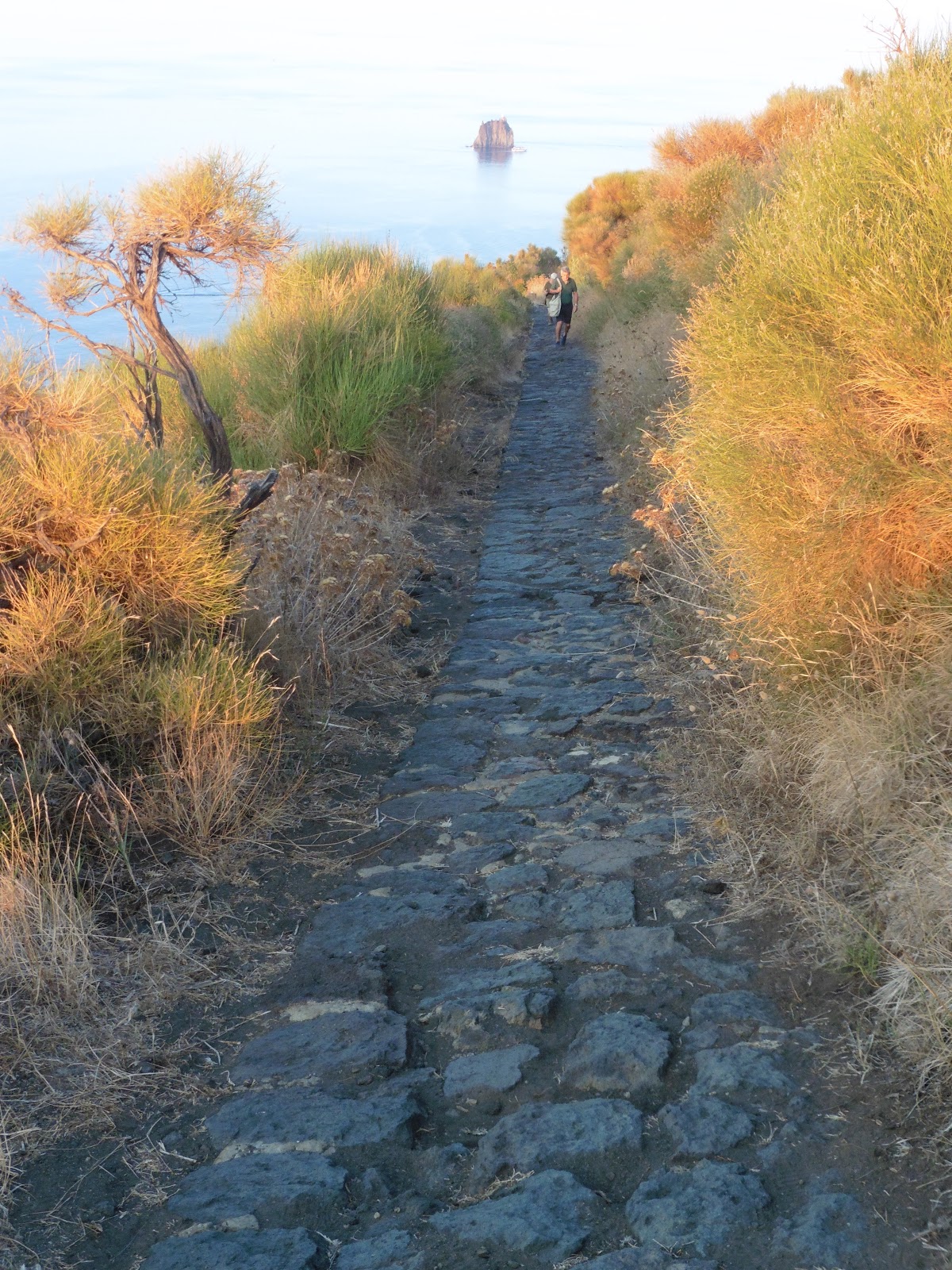
The Vette Panarea rose above the harbour, curving left & south.
It was all very lush & peaceful: maybe all the rich & famous were still in bed after disco-ing all night??
Eventually we were high enough to see the Pallas anchored offshore & the little Scoglio del Sorcio islet a little way south of the harbour.
The Vette Panarea more or less levelled off, so we had a small break at the Chiesa di San Pietro.
 |
| The mosaic outside the Chiesa di San Pietro |
I went in the church, but it wasn't particularly memorable
 |
| Panarea bougainvillea |
There was a nice mosaic at the front though, & I guess it references St Peter the Fisherman???
Unhappily, I can't find anytrhing at all about the mosaic on Google, Wki etc. :-/
 |
| Gmaps reckons this is Scoglio del Sorcio |
However, Wiki does say this about Panarea:
Panarea is an inactive volcano & is the smallest of the seven inhabited Aeolian Islands. It has a total surface area of only 3.4 km2.
There are currently about 280 residents living on the island year-round; however the population increases dramatically in summer with the influx of tourists.
 |
| Clematis? ? ? Don't quote me! |
At 421 m above sea level, Punta del Corvo, is its highest point, & there are thermal springs near the village of Punta di Peppe e Maria.
Panarea and the entire Aeolian chain were declared a UNESCO World Heritage site in 2000. Largely because of this, construction & development are strictly regulated and the community retains its storied insularity. Most residences admit only temporary occupancy, and the few year-round homes available are highly expensive & difficult to obtain.
 |
| The group pauses with Sicily? on the horizon |
I think it is quite funny there is a village called "Joe & Mary's Point" hehehe
 |
| I have used many of the photos from Panarea to make birthday cards |
After our small hiatus at the church, there was another one before we headed downhill again, so I grabbed quick pic of the group.
 |
| A different angle on Sorcio's Rock |
 |
| It wasn't me taking a cockeyed photo ;-p This was growing at an angle |
 |
| This door was tiny. No idea why I should've used stunt bum-bag for perspective |
 |
| Awesome eucalyptus above the beach |
The island is largely vehicleless (is that a word?) so we wandered unconcerned by traffic along the road to the Spiaggia Cala Zimmari: a long sandy beach about 2K from San Pietro.
It was a lovely walk & one I would like to do again - maybe one day? ;-)
So far Panarea was my favourite place in the Aeolians (although Salina had been nice as well~I think it was the scenic walks?), but by all accounts Panarea is very expensive so a revisit will have to wait until the other things on my bucket list are ticked off.
Or at least paid for!
It was all very scenic, & we meandered rather than marched to the neolithic village, everyone frequently stopping for photos.
I can see I have very few notes about the Panarea visit, but, happily, the photos & good old Google are reminding me about what happened.
My notes do say that by the time we got to Spiaggia Cala Zimmari (which - according to Google, is the only sandy beach on the island) I needed a Rule 10, & I remember wandering down off the road to a cafe near the beach in the hope of finding a loo.
There was nothing open & no-one about to ask. The place was deserted despite being gone 1030, so I got rid of the shorts
 |
| Um! As usual, I was well in front. Serge, Lorella & Jen below me |
 |
| We finally arrive |
Too much information??
;-p
I walked in the sea all along the beach, & at the south west end there were steps up to the promontary where the Bronze Age village was.
I had wrapped a towel round my middle, so I dried off a bit at the rocks at the bottom end & put my trainers back on.
By the time I'd finished the others were climbing up.
I set off at my normal pace, & by the time I was nearly at the top I had passed everyone, so stopped to take a 'where I'd been' photo.
Cala means cove in Italian & it was a pebbly little beach to the west of the promontary ~ Punta Milazzese, where the Bronze Age village was.
 |
| The map showed the site of the middle bronze age buildings |
 |
| The site had restricted access . . . |
Before they made the 20th century path where Francoise & Serge are walking ahead of me ->
it would have been a narrow, rocky route down to the village.
 |
| so it would have been easily defencible |
The pics on the left & below show how
 |
| There was just a small access route onto Punta Milazzese |
Also, the invaders would have had to fight uphill ~ now steps: see --->
so the defenders were likely to be successful ~ unless the attackers scaled the cliffs!
To save me having to remember, I took pics of the info-boards. I hope they're readable & make sense, despite the slightly dodgy translation into English ;-p


 |
| One of the oval huts |
Gmaps satellite view is great for seeing an aerial view
 |
| Scoglio del Sorcio on the horizon while the Pallas & lunch await us in the bay by Zimmari beach |
I also found a para. in the Sicily-Visitor website:
Panarea is also the site of animportant Bronze Age settlement, in a secluded bay surrounded by cliffs called Cala Junco, at Capo Milazzese near Drauto. The settlement included 23 huts, almost all with an oval shape, some also including a paving slab and other slabs of stone used as tables etc. Further archaeological investigations off
the coast have found the remains
 |
| Steep cliffs of the Punta Milazzeze . . . |
I had seen the display at the Lipari museum,
 |
| & turquoise waters beneath |
 |
| Zoomed seabirds on their nest ledge |
1st ~ Overnight to Orkney, Brodgar, Skara Brae, Scapa Flow & Kirkwall).I walked out to a very rocky area (above left) for a look round, but although the
satellite view on Gmaps suggests there are structures there, I didn't see anything obvious at ground level, so maybe they just haven't excavated that bit?
Back at the village itself, I took pics of more interesting info & remains, then it was time for us
all to head back downhill to the
Spiaggia Cala Zimmari & our zodiac back to the Pallas.
Despite setting off down after most of the others (again ;-p), I still had quite a bit of time to have a quick swim
in order to wash off he dust & sweat, & then to hunt for pumice on the beach.
I found quite a few grey/white bits of rock, which I tested in
the sea.
If they floated, they were pumice.
All but 1 did, so I put the 4 best in the bumbag.
I have since given
two to friends for their feet!
When Rahul arrived in the zodiac we inadvertently provided entertainment for bathers on the beach as we waded out & climbed aboard: the slope was too shallow for Rahul to beach it fully, so everyone had to wade out.
 |
| A rock in the middle of the Cala Punta bay where the seagulls were |
 |
| A square rather than an oval foundation |
Back at the village itself, I took pics of more interesting info & remains, then it was time for us
 |
| This map shows the access yto the village & the layout |
Spiaggia Cala Zimmari & our zodiac back to the Pallas.
 |
| This is a close-up of the script on the above info-board |
 |
| A home on the edge |
Despite setting off down after most of the others (again ;-p), I still had quite a bit of time to have a quick swim
 |
| The pumice which floated. Lumix strap for perspective! |
I found quite a few grey/white bits of rock, which I tested in
 |
| Bathers / rubberneckers on Cala Zimmari beach |
If they floated, they were pumice.
All but 1 did, so I put the 4 best in the bumbag.
I have since given
 |
| Rahul takes us back to the Pallas |
When Rahul arrived in the zodiac we inadvertently provided entertainment for bathers on the beach as we waded out & climbed aboard: the slope was too shallow for Rahul to beach it fully, so everyone had to wade out.
 |
| The village promontary from sea level showing the cliffs & the rise to the village entrance at the saddle |
Back
aboard it was sunny enough to sunbathe,
so I put the sun-kini on & washed the swim-kini: hanging it out to dry before I packed.
Then it was time for lunch before we set off back to the mainland.
During lunch it began to rain: the first all week.
That meant a final sunbathe was out, but it was still warm enough to sit on deck.
Which I did for a while ~ but under the canopy out of the rain.
The others all sat in the salon, or went to their cabins to pack.
Because I'd come with carry-on, I had very little to worry about & my packing took less that quarter of an hour.
Then I went back outdoors for the final part of the sea journey.
It was still raining.
I had my camera with me, so took some final 'at sea' pics during the journey.
The rain stopped briefly during the return to Milazzo, & there was a little sunlight peeping out from beneath the cloud, but it had become colder in the wind.
So, I went & washed my hair in preparation for my onward journey the next day, did some sudoku on my bunk, & then fell asleep for a bit to the rocking of the ship.
Lovely :-))
Our final sail wasn't very long, & soon we were motoring past the Capo & nearing the Poseidon Marina at the north end of Milazzo port.
It's a shame Pepe never put us under sail ~ especially during this last journey, because there had been a fair bit of wind, and it was blowing in more or less the right direction.
When I'd asked Pepe early on in our week aboard, his answer suggested that the keel was the wrong shape for choppy seas or to raise the sails unless the wind was perfect & the sea relatively flat.
Ah well.
It had been a great week
on the water anyway, & the islands were great :-D
I would defo like to make another visit.
Once we tied up there was some free time before our last dinner aboard, so I went online to try & check out the times of the buses back to Messina for my train connection to Giarre ~ where Armando was to collect me from the station.
Unfortunately, there was no web connection, so that was a bummer. Plus, my attempts were depleting the battery, so I put it on charge while we had dinner ~ during which I finally let Philippe know I spoke more French than he'd thought.
It was amusing to think he'd be realising that I had understood all his rude comments about the English & England!
Serge & Francoise had organised an 'envelope' for us to insert a tip for the 3 crew & Nicholas, so after dinner I put some Euros in it wrapped up in a short message of thanks.
Then I tried to get online again, but I still couldn't. Eeek!
However, all was not lost because I had done some prep. before leaving the UK & had checked again on the way out, so I hoped it was all correct & that I'd find my bus & get to Messina in time for my train ~ I had already E'd Armando & told him I expected to arrive at Giarre before midday on the 9th.
Just to be sure, I planned to set off immediately after breakfast & hoped to go to bed soon after dinner, but with all the general chat it was gone 1am before I hit the sack on my last night aboard the Pallas.
Tomorrow I was off to Etna (& if you've read any of my other blogs, you'll know I have a 'bit of a thing' about volcanos! ;-)
OAO
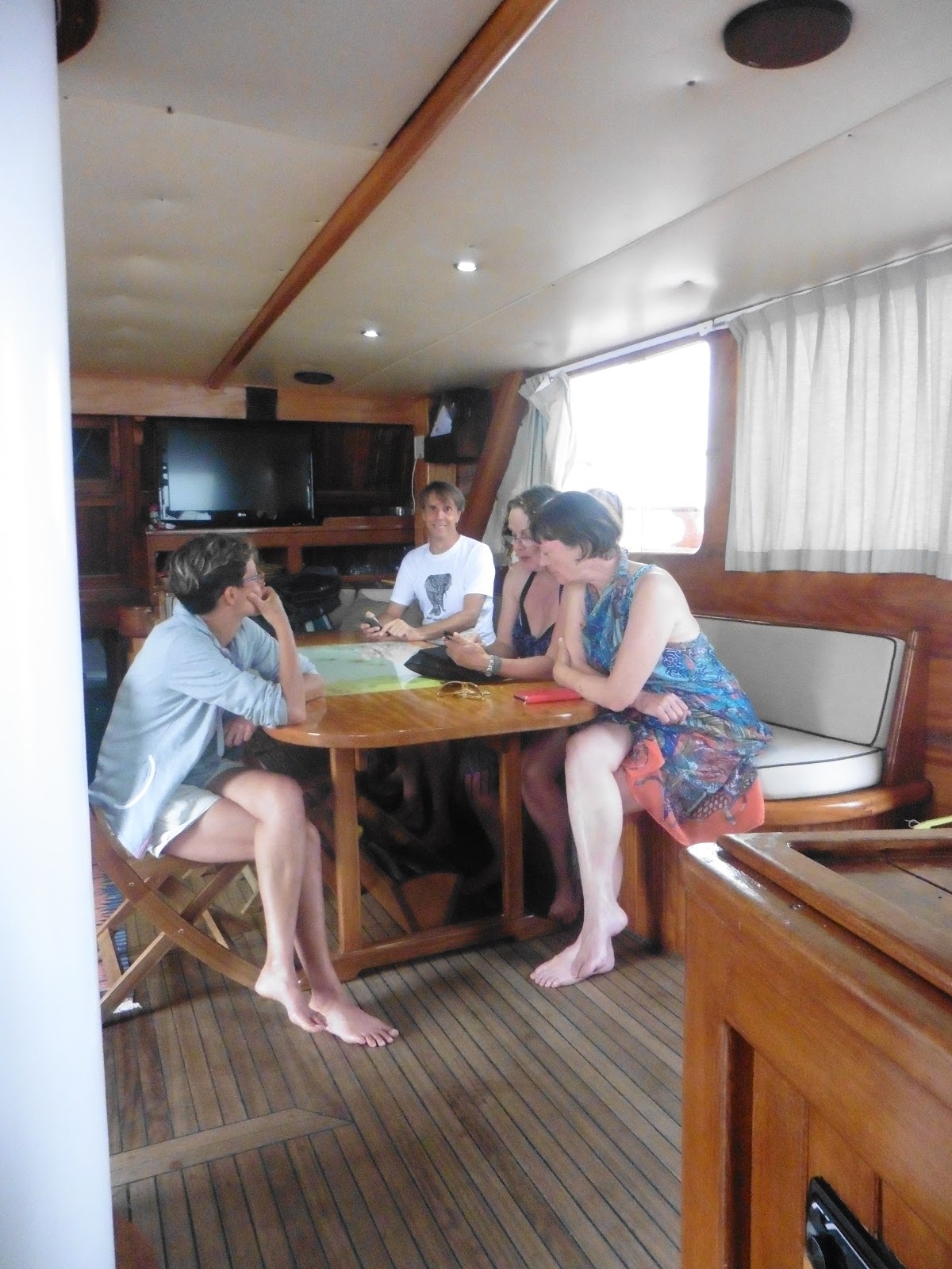 |
| Discussions in the salon because it was raining! |
 |
| The sunbeds were too wet to lie on . . . |
 |
| unless you were beneath the canopy! |
 |
| We approach Milazzo |
Then it was time for lunch before we set off back to the mainland.
During lunch it began to rain: the first all week.
That meant a final sunbathe was out, but it was still warm enough to sit on deck.
Which I did for a while ~ but under the canopy out of the rain.
The others all sat in the salon, or went to their cabins to pack.
Because I'd come with carry-on, I had very little to worry about & my packing took less that quarter of an hour.
Then I went back outdoors for the final part of the sea journey.
It was still raining.
 |
| Not sure wot's goin' on 'ere? |
The rain stopped briefly during the return to Milazzo, & there was a little sunlight peeping out from beneath the cloud, but it had become colder in the wind.
So, I went & washed my hair in preparation for my onward journey the next day, did some sudoku on my bunk, & then fell asleep for a bit to the rocking of the ship.
Lovely :-))
Our final sail wasn't very long, & soon we were motoring past the Capo & nearing the Poseidon Marina at the north end of Milazzo port.
It's a shame Pepe never put us under sail ~ especially during this last journey, because there had been a fair bit of wind, and it was blowing in more or less the right direction.
 |
| The Pallas in Milazzo |
Ah well.
It had been a great week
 |
| I was headed to the slopes of Etna next day |
I would defo like to make another visit.
Once we tied up there was some free time before our last dinner aboard, so I went online to try & check out the times of the buses back to Messina for my train connection to Giarre ~ where Armando was to collect me from the station.
Unfortunately, there was no web connection, so that was a bummer. Plus, my attempts were depleting the battery, so I put it on charge while we had dinner ~ during which I finally let Philippe know I spoke more French than he'd thought.
It was amusing to think he'd be realising that I had understood all his rude comments about the English & England!
Serge & Francoise had organised an 'envelope' for us to insert a tip for the 3 crew & Nicholas, so after dinner I put some Euros in it wrapped up in a short message of thanks.
Then I tried to get online again, but I still couldn't. Eeek!
However, all was not lost because I had done some prep. before leaving the UK & had checked again on the way out, so I hoped it was all correct & that I'd find my bus & get to Messina in time for my train ~ I had already E'd Armando & told him I expected to arrive at Giarre before midday on the 9th.
Just to be sure, I planned to set off immediately after breakfast & hoped to go to bed soon after dinner, but with all the general chat it was gone 1am before I hit the sack on my last night aboard the Pallas.
Tomorrow I was off to Etna (& if you've read any of my other blogs, you'll know I have a 'bit of a thing' about volcanos! ;-)
OAO