Day 9 ~ Nov 28th: Fullers Dolphin Day Trip
Today was the day of the long boat trip, & another hope that I might get in the water with dolphins.
It was an 9am start at Paihia jetty, so I was up early to get a parking spot somewhere nearby. Sadly, this wasn't to be, so leaving my day-sac with Fullers, I drove back to Peppertree as I knew I could leave the car all day there.
It did mean I had to jog back down the prom., though :-/
Plus, I still hadn't been able to send the E to Kev I'd written the night before. Bugger!
After check-in back at Fullers, I nipped to Countdown to get some nosh for on-board ~ 2 punnets of cherry tomatoes & 2 bananas. There was still time for a coffee at the jetty cafe as well, so I wrote up yesterday's blog notes while I waited.
We boarded at 0920, & the Skip was a lady. I couldn't read my hieroglyphs, so I E'd Fullers today (Jan 19th '16), & it's Tammy :-)
The cat was called Tangaroa III, & we cast off for Russell on time.
 |
| Leaving Paihia. I was the only one on deck |
 |
| Approaching Russell |
 |
| This was berthed at Russell |
 |
This little house was right next to the
Russell pier. Nice spot! |
Once the Russell passengers were aboard, we had our briefing about the day, & the chances of a swim with the dolphins. It was the same rules: no swimming with young or pregnant in the pod.
Names were taken, & mine was one (of course), despite the chill.
The tour initially went in more or less the same direction as Sunday's, so I didn't take many more pics.
However, once the dolphins came out to play as we headed out to the NE past Motuarohia, Moturua & Urupukapuka, I got clicking.
 |
Motukokako & Tiheru
A good view of the elephant effect |
We sailed out to Motukokako & Cape Brett again, & I got some more pics of the 'elephant with its trunk in the water'
 |
I have a note about Cathedral Cave.
I don't know if this is what I meant? |
 |
This was off the NW edge of Motukokako & shows
a shoal of fish having breakfast/brunch/lunch |
 |
| As is this. I've blown it up so you can see the fish under the water |
On the way back, I went in the cabin with Tammy, & we had a chat about Treebeard & other LOR & Hobbit stuff. I was up there for 20min.
Given the manky weather, it was defo the best place on board! :-)
Sailing kinda SW, we passed Motuarohia, Otehei Bay (where the author Zane Grey lived), Motukeikei, & sailed through the gap between Okahu & Waewaetorea. The former is a Maori chief's name &, apparently, a waewaetorea is an oyster catcher's footprint.
 |
Nine Pin Rock. No idea why it's called Nine Pin.
I think the white streaks are guano? |
Out north & west towards Nine Pin was next, & then to Rangihoua Bay where there is a 28' Celtic Cross.
After that we went past some of the Te Pahi islands, & SE to the Black Rocks.
Apparently these were created by pillow lava rising up & then quickly cooling. The columns are similar to the Galapagos and the Giant's Causeway in Antrim (according to google, anyway)
I need to mention the gannets*. I love them :-) They were amazing to watch as the dived into the water as we sailed by.
There will be a Lot of gannets in the Aurora blogs, but I won't be writing that for a while yet.
 I got the photo above off Trip Advisor. It shows the columns much better than my murky pics!
After the Black Rocks in the rain, I chose to go below & took a pic of someone else's pics of Motukokako.
They clearly show how the tide affects the size of the hole.
Back east, we sailed towards Assasination Cove, catching sight of dolphins quite often. The cove was named after a French sailor & crew were killed & eaten (apparently!)
Shame about the rain, but it didn't stop the dolphins from having fun & showing off :-)
Happily the skies cleared, & by the time we got to Otehei Bay on Urupukapuka (as on Sunday), the clouds had nearly gone.
 |
Not sure, but I think the big-leaved tree is a Pukapuka?
If so, then this little group of trees would be
urupukapuka in Maori. Hence the island's name. |
I didn't disrobe & swim this time, but had a wander around the little hamlet by the jetty, & took some vegetation pics.
At some point - while we sailed in the rain, I'd also had some ham butties, a glass of Brut Lindauer, & a cup of English Breakfast with my tomatoes & bananas.
Well, it had been a long morning :-q
As we left the bay I sat & chatted to Michael from Singapore for a while, & we had both picked up a shell from the beach. I chucked mine back overboard, though. Apart from the Eco issue, I didn't reckon it would survive >3 weeks travel!
My notes say that the way we sailed next went past the Rawhiti area, & on to Parekura Bay, Manawaora Bay, another visit to Assassination Cove, & out past Motuarohia again.
Back at Otehei we picked uploads of new passengers from another boat - I think it had broken down??
As a result we doubled the numbers headed back to Russell & Paihia.
The way home passed Motuarohia (yet again!), & we rounded Tapeka Pt. at 1600. We got into Russell 10 min later, & disembarked at the Paihia jetty about 20 min after that.
Walking back to Peppertree it was threatening to rain again, so after a quick check for food deals at the supermarket, I reached the hostel in time for a reasonably early tea.
Given it was summer & still fairly light, I took a quick pic of the patio at Peppertree. For a change, there weren't any smokers there!
Day 10 ~ Nov 29th: Paihia to Omapere, Tane Mahuta, & south via Dargaville
 |
This was taken on a bend on the SH11,
the main road south out of Paihia |
The drive south began with a couple of early morning Paihia shots, & then I loaded the car, checked out, & set off before 0800.
 |
| Final pic of Paihia bay |
I chose to go out along the prom & west on the SH11 rather than retrace the winding route from the south I'd driven in on.
At the SH1 I went left towards Kawakawa, & passed through Moerewa before realising at Kawakawa I should've gone right. Oops
Doing a U-ey just out of town, I retraced my steps & headed off SW on the SH12 at Ohaeawai.
The road to Kaikohe was very quiet, & after passing through it, the SH12 meandered SW-ish under Hokianga Harbour. This is a massive inlet on the west coast of Northland between Kaitaia in the north & Dargaville in the south.
At some point I picked up a hitcher. I think he said his name was Pungi, but his accent was so thick I'm not sure. He was headed to Opononi, & I took a pic of the jetty there after I dropped him off.
 |
| Opononi jetty |
Next stop was Omapere (just round the corner) where the inlet meets the sea, & the sand there was really white.
 |
| The line of surf is the Tasman Sea |
 |
| Looking back into Hokianga Harbour |
 |
| Another view of the Tasman in the distance ~ & more dunes |
 |
| Omapere: a pointy hill & a more pointy hill |
 |
| Pointy hill with Arai Te Uru headland to the right |
I spent quite a bit of time in Omapere, as I'd seen a very pointy hill I wanted a closer look at, & ~ while exploring the options, I found a DOC parking spot & cliff walk. It was the Arai Te Uru Recreation Reserve, & I got some nice pics there. No info about the pointy hill, though :-/
 |
| From up on Arai Te Uru into Hokianga Harbour |
 |
| From Arai Te Uru north along the Tasman coast |
As well as a walk onto Arai Te Uru, I topped up the car in Omapere, & got a coffee for me. It was about half past 9, so despite the unintentional detour into Kawakawa, I was making good time.
Continuing down the SH12 ~ which wiggles more or less parallel to a very straight west coast, I entered Waipoua Forest at 10 to10 ~ Bonanza time ;-p
 |
Hokianga Harbour is the big blue bit pointing between 8
& 2 o'clock, & Waipoua lies between it & the
little oval lake near the coast.
You can see my reflection in the glass! |
There had been a lot of brown signs about Tane Mahuta, yet the car park was little more than a big lay-by.
While I took photos of the maps, a big group of bikers rode up, & they followed me into the forest along a little wooden walkway.
 |
| Wow! I wish I could hug it |
I am making no apologies for the number of Tane Mahuta photos
on this blog!
If you've read any other blogs I've written, you will understand about me & trees ;-)
Besides, it's a totally awesome tree & deserves to be seen.
 |
| A zoom of the amazing bark pattern |
 |
The tree & me
Taken by KJ et al |
There was a little viewing area with seats about 15m from Tane Mahuta, but even with maximum wide-angle, I couldn't get it all in. That's why some pictures show the top leaves & some the base. I carried on round the path to see if I could get a better shot, but even then it was difficult to get the very top & the very bottom.
Back at the seats I found the bikers all posing for photos, & I offered to get them all in 1 shot as a memento of their road trip.
Sadly, the top & bottom problem meant I had to cut the top off the tree, and cut everyone's legs off :-/
I think I took about 4 with their various cameras, & gave my card to KJ, asking him to E me a pic.
Happily I did get an E from KJ (AKA Kevin) about a week later & he attached the photo.
This is it:
 |
| The lads & a big tree |
Awesome. Thanks a lot Kevin :-)
Here's a bit off the web about Tane Mahuta:
Maori Legend | Tane Mahuta
In the beginning before the world was light, Rangi the sky-father
and Papa the earth-mother, were bound together, their offspring
trapped in the darkness between them. The sons became
desperate for light and space, so agreed to separate from their
parents. The strongest among them, Tane Mahuta, put his
shoulder to Papa and thrust upwards with his powerful legs,
disregarding the protests of a weeping Rangi and Papa, as
they were wrenched away from each other’s embrace. Tane
Mahuta pushed upwards with all his great strength, until Rangi
was forced far away up into the sky, and Tane held him there,
letting the light shine in.
Artist Jane Crisp‘s stunning interpretation of Tane
Mahuta separating his parents 
Unfortunately, only the left-hand side of the painting copied. If you google it, you'll be able to see what's on the right-hand side.
Even 1/2 of it is still awesome, though.
 |
| Driving through Waipoua Forest |
Leaving the lay-by, I continued south for a few miles & saw a sign for a Scenic Lookout off to the right. Following the track up for another couple of miles, I found an old fire lookout tower.
Climbing up it, I took two more pics: This time of the forest from above.
 |
| Waipoua Forest from the viewing platform |
 |
| Ditto |
Back on SH12 I stopped to take this pic of the sign, before continuing south to Dargaville.
 |
The sign if you drive north.
I missed the one driving south |
The SH12 enters Dargaville from the north-west, & takes an easterly curve through the outskirts. When it reaches the Wairoa ~ as the river turns sharply to the south, the SH12 goes back north-east. However, I was in need of ice-cream so I made a brief stop at a shop near the turn to get one.
I managed to eat it sitting in the car on the river promenade, before heading off again.
Following the SH12, I turned right to cross the Wairoa & took this photo out of the window.
 |
| The very sandy Wairoa River at Dargaville |
It was still sandy 12 miles later.
 |
Looking back up the sandy Wairoa river from
Donovan's Bluff, Tokatoka |
After the Dargaville bridge, the roads were amazingly straight - a bit like the SH1, SH73 and SH77 going through Canterbury out of Christchurch but after a bit I was aware of a very pointy peak. Even more pointy than the one at Omapere.
I'd gone too far along the SH12 before I decided to stop for a pic, & I couldn't get a great one from the lay-by where I pulled up, but the river was still very pink, & it was another excuse to stop & gawp :-).
I got a pic of this engraving at the lay-by, & while having a shufti on google, I came across a great photo of Tokatoka itself. But it disappeared after publishing :-(
Then it was time for a loo & brew stop, so when the SH12 turned sharp left away from the river at Ruawai, & I saw a sign mentioning free wifi, I pulled over. It was 1230.
I had a facebook message about the Hobbit song "The Last Goodbye" sung by Billy Boyd. He'd been Pippin in LOR, & sang in the final film. So, I had a listen.
Well, I was in tears, wasn't I?
Blimey! Talk about tugging at the heart-strings. Good job the cafe was nearly empty :-0
My notes written at the time say:
"Checked out Last Goodbye vid & posted comment - needed tissues!"
Fortunately, the coffee & cake came with a nice big serviette :-p
Cake & coffee consumed, & Es read, I eventually continued along the SH12 more or less easterly towards Brynderwyn & the SH1 junction.
Interestingly, Gmaps show me that the Wairua River originates from right across to the north-east above Whakapara & not far from Russell Forest. It eventually joins the Wairoa just north of SH14 in the Wheki valley, & between them the 2 rivers almost cut Northland in half.
Anyway, back on the road, I went right at Brynderville & followed the SH1 down into Auckland.
At some point I passed signs for tolls, & got some money out but there were no toll-booths. I later found out I should have either pulled over into an area where you paid, or gone on-line to pay it. I was in New Plymouth 3 weeks later before someone explained this to me & took the fine for the non-payment of a toll off my card. Bummer!
I thought I'd try & fly to Whakatane, drove to the Domestic Terminal, but no luck ~ flights were more than £100.
Heck!
I'll stick to the bus, ta :-0
After that, I eventually found the car hire garage after going to & fro twice. They dropped me off at the Domestic, & I got a $16 shuttle into town. It took ages :-(
However, it dropped me off just a few yards from Base Auckland where I was staying that night.
Base is a dump ~ don't stay there! It's noisy & dirty, & the only plus was that it was only 5 min from my bus stop for the early start next morning.
Having dumped the big ruckie & my green wheelie in the room, I went into Starbucks where I could get free wifi ~ I would've had to pay at Base.
I had tea & a free hour, so I tried to find out about the toll & sent an E to enquire.
Back at Base, I ate & did some sudoku in the large dining room. As no alcohol was allowed, I washed out my milk bottle & hid my wine in that. It was the sweet one from Ake Ake.
 |
| The dorm at Base Auckland |
Like I said, Base was a bit of a dump.
In my dorm there was very little space for anything, & the only bed left was a top one. When I went to bed, the light was already out, 2 peeps were in bed asleep, & 1 was on their laptop. It was about 10 o'clock, but I only managed a short kip, before 11ish as a load of Spanish were making a racket in the corridor & woke me up. Passing their impromptu corridor party on the way to the loo, I noticed there were about 15 of them all sitting or standing in the corridor, & music was coming out of one of the dorms.
I went back to bed, but the racket was still ongoing at 1.45, so I got up, got partially dressed, & took my bags down to reception.
After waiting about 20 min. ~ because there was only 1 person on, & peeps were still waiting to check in (would ya believe it at 2am??), I got to the front of the queue & explained my problem. I was given another key with no argument. It was on the 7th floor, & exceedingly pink, but there was only 1 other girl in there, & it was blessedly quiet.
Sleep at last. Lovely. Even though it would only be for 4 hours.
Day 11 ~ Nov 30th: Aukland to Whakatane
I got up at 0645, & left Base without food or drink. The bus stop was less than a 10 minute walk, & the bus left on time at 0740.
I was sat next to a guy from Suffolk, there were 3 loud French on the front seats, & the driver was called Kevin. Once the French had got off at Thames, I switched to the front seat and chatted to Kevin, explaining I was aiming for Whakatane, but couldn't get all the way because there were no buses there on a Sunday. My ticket was to Tauranga, & hearing me call it Tau*-ranga ( * like the 19th letter in the Greek alphabet), Kev said it was Toe-ranga. He also said I could stay on until Mt Maunganui as it would be easier to hitch out of the town centre there than in Tauranga. What a nice guy :-)
 |
| Taken from the bus leaving Auckland |
We arrived at Mt Maunganui at 1150, & I set off along Maunganui Rd towards the SH2 junction.
After walking about 10 minutes ~ as I passed a guy getting into a Jag, he asked me where I was going. When I explained, he said he'd take me a little way up the road out of town. It turned out that Gordon was from Canada.
 |
| Mount Maunganui |
Gordon dropped me off a bit further along Mt Maunganui Rd., & after about another 15 min. walk, I got another lift to the fly-over on the SH2 where there was a petrol station. This time the guy was called Greg, & he was a Kiwi. He suggested I wrote Te Puke on my sign, as it was more likely peeps would be driving there rather than all the way to Whakatane, >80k along the Bay of Plenty.
At the garage I went into the Ladies & wrote Te Puke on the back of my piece of cardboard box, & then made my way up the ramp. As it was a freeway, I couldn't walk along the road, but after standing just a few minutes, a German girl called Gerda picked me up. She was going to her place in Te Puke, but she took me all the way through & out the other side so I would be more likely to be seen by peeps continuing to Whakatane. Te Puke is about 23k from Mt Maunganui, & it had taken me just over an hour.
Gerda was very sweet, gave me a hug when I left, turned her car back towards Te Puke, & waved out of her window. Bizarrely, as I was waving back, another lift stopped. This time it was a Maori chap called Gilbert, & he was the 4th of 4 lifts whose name began with a G.
Weird or what?
Anyway, Gilbert took me all the way to Karibu Backpackers, & pointed out that 'the best fish & chip shop in Whakatane' was just round the corner.
 |
| Karibu Backpackers at Whakatane |
Kieth, the Manager/Owner of the hostel, showed me my room, fitted me out with some directions to town, & then suggested I had a single room in one of the bungalows rather than a dorm. Nice one, Keith :-)
It was a small bungalow - 1 of 3 on the east edge of the property, & I was to share it with John who was working in Whakatane. John was from Christchurch.
I was pretty ravenous, having not had much lunch ~ & no breakfast to speak of either, so I walked straight round to the fish & chip shop. My hieroglyphics say I had taheki & chips, but google hasn't heard of taheki, so I obviously fell foul of my hieroglyphics again! Reading later notes, it seems it should be tarahiki? Here's what Google says about tarahiki:
The tarakihi or jackass morwong, Nemadactylus macropterus, is a morwong of the genus Nemadactylus, found off southern Australia, the Atlantic coast of South America, and New Zealand to depths of about 400 m, on all types of bottoms. Its length is between 30 and 60 cm.
If I'm not careful I'll be wasting time looking up morwong next ;-p
I think it sounds like a name of a monster in a fantasy novel :-0, but it's very tasty, all the same :-q
The girl who served me was from Barnsley ~ fairly close to home!, & she also gave me a proper cup of tea - nice & strong :-)
I walked into town eating my fish & chips, & found the I-site so I could check out my departure point for my day trip to White Island (Whakaari in Maori). I also asked them about paying my toll fee, & she suggested Keith may be able to help. After that I had a quick look round town, found a pharmacy that was open & got some more anti-itch pills, & had a brew in an Irish pub called The Craic.
 |
| Whakatane marina |
I walked back along the river for quite a way, as there was a nice pathway right along it.
 |
| Moutohora Is behind the trees by the Whakatane river |
On the way along the path I passed the time of day with a bloke walking his dog, & he recognised my northern accent. He was Paul, & was from Manchester. We chatted for ages before I carried on along the river. I left the river path at Eivers Rd., & found my way back to Landing Rd. where Karibu was.
On the way I called into a Pak'nSave and got some grub ~ incl 2 sheep hearts.
There were bits of food left over from being in Northland, so as tea & coffee were free, I brewed up, & for my tea I made a mix of what I'd bought & what was left.
I took a pic of my little room & my hitching sign while it was cooking, & then cooked the hearts for tea over the next 2 days. I put them in the ice box to freeze overnight & went online while the sun went down. I tried another E to the Toll people, & E'd various peeps.
Chatting with John & Keith out on the little patio, I found that Keith was going into town 1st thing, & he kindly offered to drop me off at White Island Tours.
Kiwis are so helpful & friendly.
No wonder I love visiting :-D
 |
| My hitching sign in my Karibu room |
The next morning I was due another earlyish start for my trip to White Island, & after that, a fairly long drive round to the top of East Cape to Te Araroa , so I was in bed with the sudoku by 9.
OAO


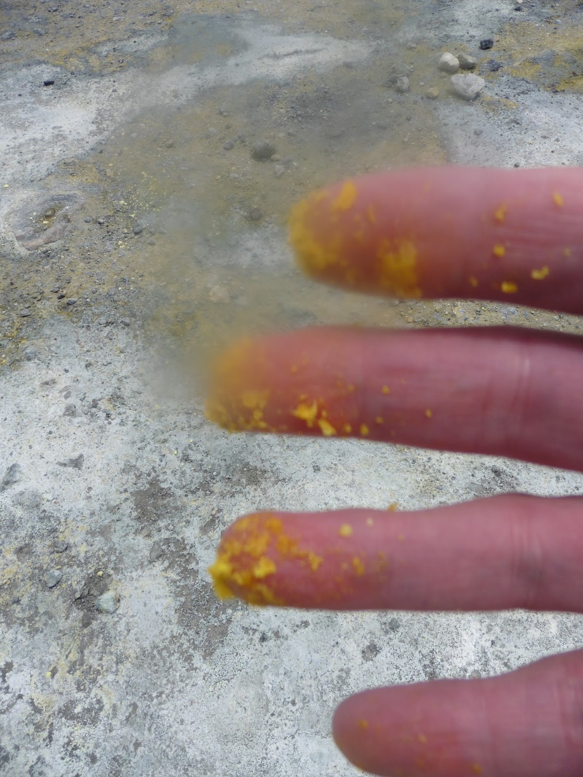
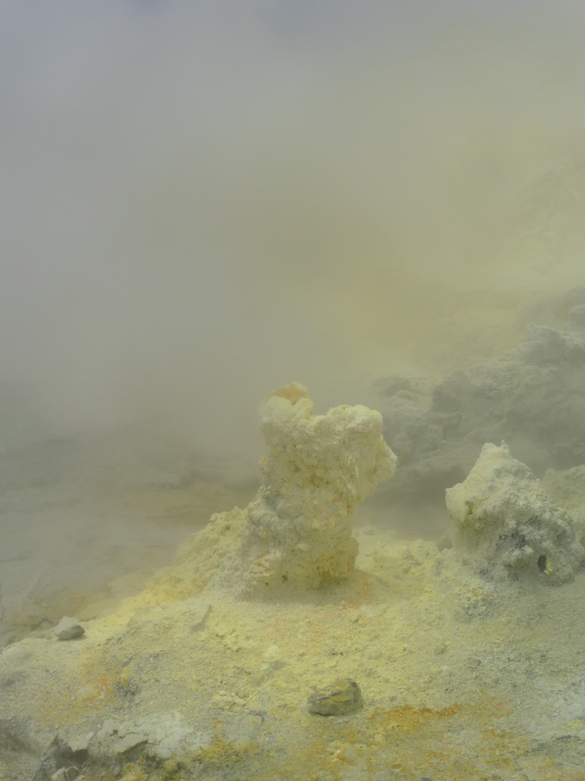
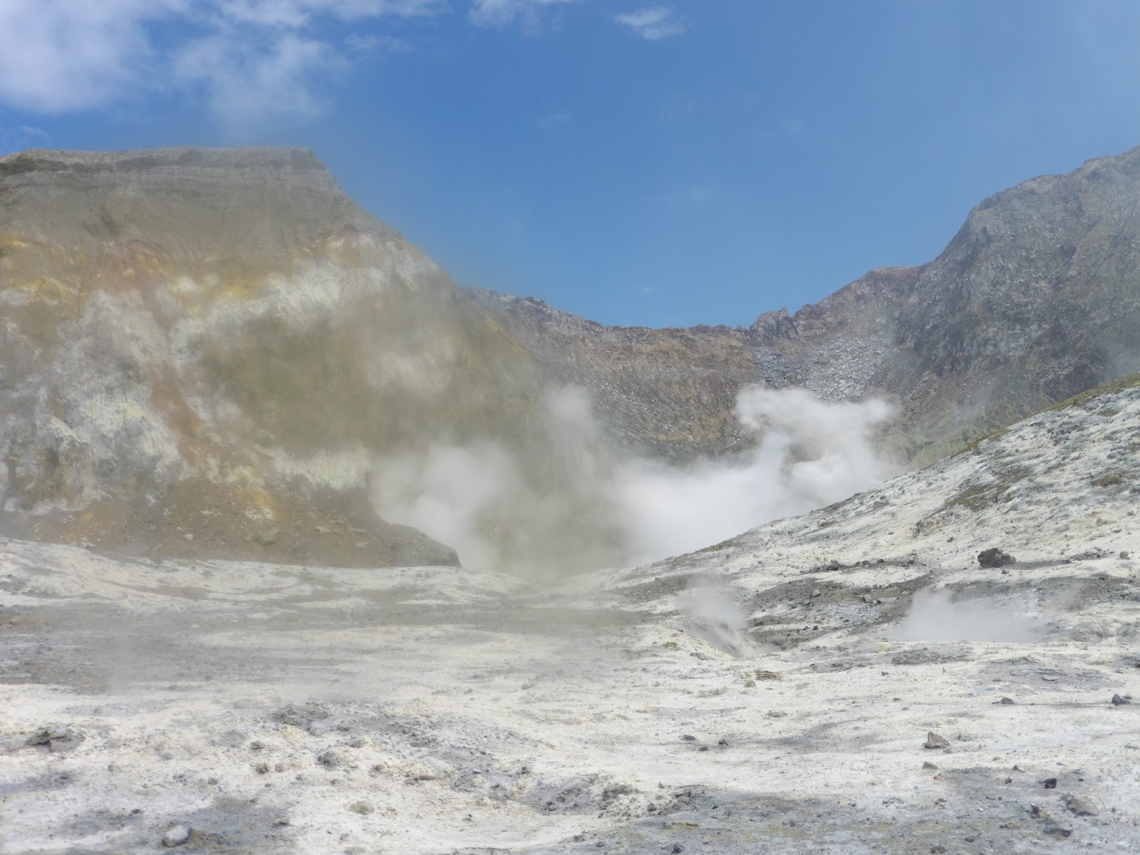 Like I said, it was pretty colourful, & quite beautiful in an other-worldly kind of way.

 So, here're a couple from Google, so you can see how brown they were.


