Day 5 ~ Nov 24th: Mangonui to Cape Reinga & Waitiki Landing
 |
| A row of shops at Mangonui |
 |
| Road north on left, Doubtful Sound on right, & penguins in the middle |
Next morning I was still itching & had big red spots all over the place, so after another cold shower, I asked Reception where there was a pharmacy or a GP. There were both at Coopers Beach, apparently, so after a brief walk round the village & a couple of pics, I set off towards the north again, & found Coopers Beach up the SH10 a bit.
 |
| Coopers Beach looking north-west |
 |
| & east back towards Mangonui |
She also suggested driving with the blower on cold, staying with the cold showers, & getting some strong fly/bug repellent.
Advice duly taken, & the 1st lot of pills swallowed, it was back on the SH10, but because of Doubtless Bay, I was headed west.
At Taipa the tide was in, & I crossed the river Oruru before stopping to get some juice & a Rule 10.
 |
| The tidal river Oruru going under the road at Taipa |
 |
| This bit of an ancient Kauri is on the ground floor |

 |
| This it what it looks like from the other side |
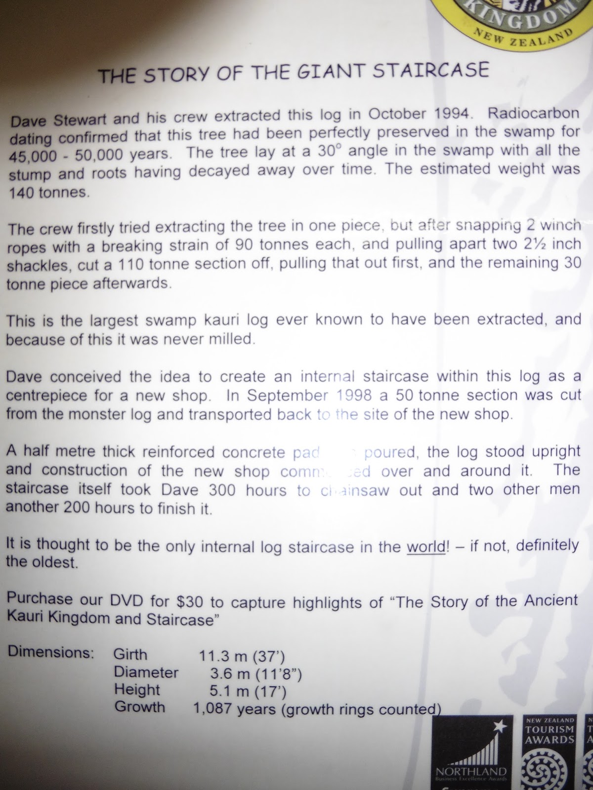
The most interesting bit about the place was the staircase inside a massive Kauri. There were Kauri souvenirs, but although I like the tree, its wood is nothing to write home about, & because the souvenirs were made from ancient Kauri, they were an arm & a leg.
 |
| Going down |

Somewhere to my left was 90 Mile Beach, & the plan was to drive down it on the way back from Cape Reigna.
Meanwhile, back on SH1, I saw a sign for a buried Kauri forest, so detoured right of Far North Rd. for a few miles to find it. It's called Gumdiggers Park, & there'll be a link on Google at:
Gum Diggers Park - Ancient Buried Kauri forest and Gumdiggers Park ...


 |
| Trench left once Kauri is lifted |
I spent quite a while there, but as I'd be walking through bush, I had a mega spray of anti-bug first.
 |
| Massive Kauri trunk by a walkway |
 |
| The base of a Kauri |
 |
| The hole is about 3m each side ~ big trees! |
 |
| NZ bush from the viewing platform at Gumdiggers Park |
Parking up I knocked, but there was no-one about, so I got back in the car & continued north for about 20k to Cape Reinga.
Once out of the car I found a handy post & took a pic of my swollen left hand. Yuk, or what?

There was a nice walk down to the lighthouse, shame it wasn't sunny, but at least it was only drizzling a little bit. It was windy, but that was OK, it kept me cool & less itchy.

Cape Reinga is a famous Maori site, & Wiki will tell you all about it. I tried putting a link, but it didn't work.
 |
| Not sure what these plants are, but the lighthouse is just to the left of the right-hand stalk, & you can see where the waters meet |
 |
| The ridge of cliffs is along the South Pacific side of the headland, & a little beach is on the Tasman |
The line headed from the headland behind the right-hand stalk to about 11 o'clock on the pic, is the one between the Tasman Sea (left) & the Pacific Ocean (right).
 |
| This is a close-up of the previous, & shows a tree fiercely hanging onto a cliff ledge |
There's a clearer line on the close-up: The Tasman is the one with the waves at the bottom.
 |
| Cape Reinga Light |
 |
| Same ocean, beach, cliff & tree cliff from another angle |


The golden sandy hills to the left are the beach are exactly that. Massive sand dunes are all along this part of Northland & the famous ones at the end of 90-mile Beach are called Te Paki

By the time I got back to the car, the drizzle was fairly heavy, so I sat & had some fruit & juice before heading back to Waitiki Landing.
Happily, mine hosts were back, & showed me my bedroom & the kitchen. It was all pretty basic, but I settled in, & made some tea ~ washed down with the rest of the Gewurtz I'd opened in Mangonui.
I'd done about 180k, so I called it a night fairly early & sudoku'd in bed for a bit.
Sadly, I woke itching like mad, & ended up in the shower at 0130 & again just before 4 :-(
Day 6 ~ Nov 25th: The search for electric, 90-mile beach & Te Paki dunes
Waking before 9 I got up & found out that the electric was going off throughout nearly all of Northland above Kataia at 9.30. Eek! Camera battery problem :-/
If I'd known, I'd've put it on charge the night before. Ah well.
I knew there was a village called Te Hapua on the coast to the east, so I set off in the hope I could buy another battery, or recharge on someone's generator.
The road there was to the right just north of the digs, but within a few hundred yards turned into another of NZ's dirt tracks.
There was some nice vegetation, & I took a couple of pics with the last of my battery power.


Te Hapua is a small village in a huge inlet called Parengarenga Harbour. The harbour's off Great Exhibition Bay, & according to Wiki, extends 10k west of the entrance. Wiki also says the Kokota Sandspit is the source of the purest white silica. The sandspit is at the southern end of the harbour, & the sand was collected for glassmaking until 1997.
The sun was out, so I had a paddle & did some sudoku. It was very peaceful, & having driven down & seen the views, as there was no shop with a generator for electricity, I decided to make a return visit once my battery problem was fixed.
While I there, I saw that it had a rugby pitch ~ what a surprise! Not ;-p
A Maori guy came by carrying a ball while I was looking at the horses grazing along the front. He also had a carrier bag full of fish & wanted to sell me some, but as I needed to go south to try & charge the camera, I declined. Fish in the car all day was not recommended!
Back on the SH1 & headed south, I picked up Ronnie, a young Maori hitching from just south of Te Kao. I took him to Awanui, & on the way he tried to chat me up (he was in his early 20s ~ haha). As usual in these situations, I casually mentioned the JuJitsu & the boxing, & that seemed to cool his ardour. Hehehe ;-).
I filled up at Awanui & drove on to Kaitaia, arriving at 1250. I stopped off at the library for the loo & some local info to find most shops were open & had electric. However, being a total techno-doofus I had packed the new mob charger & not the new camera charger. Grrr. Dizzy blonde :-/
One of my plans for the drive south on the 26th was to drive 90-mile beach south, & eat lunch at Ahipara, but as I was already down there I decided to do it in reverse.
Sadly, Ahipara seemed to be closed for the day, so I drove back to Kaitaia, ate at the library cafe & sent an E to Bat.
Having decided to drive north along the beach, I went back to Ahipara & spoke to a guy in a surf shop by an entrance to it. He said not many cars had gone past that day & suggested I didn't go. So, with safety in mind, I pointed the bonnet at Kaitaia again. Happily, just at that moment, a 4x4 drove up, so I flagged him down & asked him about getting on, & could I follow him?
He said he wasn't going all the way up, but told me to follow his tracks down onto the beach as the sand was pretty deep once the road ended & before the hardpack started.
I managed to follow him on without much trouble & set off along the beach, remembering Jeremy Clarkson's drive along it on Top Gear.
 |
| The 1st pic of 90-mile Beach using my Nokia |
 |
| The tide was still going out |
 |
| My guide's 4x4. I never got his name |
 |
| We had the sea on our left, and as the beach was very flat & hard, it made a great highway |
Coming back south there were cars, 4x4s, coach trippers & quad bike. I didn't see any ordinary bikes, tho.

He described a dome-like hill just south of the best exit, so I set off alone while he got on with his fishing.
 |
| A big piece of driftwood |
 |
| Virtually the same view as the next, but no walkers |
 |
| The walkers were obviously intent on walking the beach & weren't looking for a ride |
Periodically I passed people who were probably looking for shellfish, & at one point I stopped to clean the window again. I walked to the surf for a paddle & to wet the socks for another attempt to clean the screen. I also put a bit of sea water in an empty ginger beer bottle, & that worked reasonably well. Better than the socks, anyway.
While I was there I picked up a white stone as a memento of my drive & paddle in the Tasman Sea. A swim would have to wait: it was too frikkin cold & lonely!
Eventually, I saw another group of shell-fishers by a little gap in the dunes. Pulling up, I looked back at them, & spotted the domed hill. Google just told me it's known as Hukatere Hill.
Leaving the beach through the gap, I found myself on another of NZ's dirt roads, & stopped for a pic of the hill.

The road went inland on Hukatere Rd through forest for a bit & continued onto what seemed to be ex-forest.
 |
| The ex-forest. There were lots of stumps |

As usual, I was the only car about, but after travelIing NE through the ex-forest & then farmland, I eventually hit the SH1 near Houhora, & turned north. When I looked at the map, I had hardly gone 1/2 way along ~ @37k.
Back at the digs, I found the electric was back on, so I put everything on charge & got some tea.
Tea was kumara with sesame seeds sprinkled on, then figs & the hibiscus & rosehip tea I'd got cheap in Paihia. I also opened the chambourcin from Ake Ake.
There was a 9 person group from Opua staying at Wataki Landing & we had a bit of a chat over tea. They were Wendy, Wanda, Walter, Joan, Ann, Richard, John, Rosemary & Murray. One of the blokes took the piss out of my Northern accent!
Come 1920, I set off again. This time north to Te Paki dunes in the hope of getting some sunset pics. The road there went left off the SH1 after about 5k, & it soon turned into another dirt track.
 |
| Dirt track to the Te Paki dunes |

I was the only person in the car park, & it was a teeny bit spooky.
 |
| You can just make out my little car across the stream |
On the car park pic above, the stream is between the dune & the car park. On the next pic below, it curves round the big dune on the right , & heads out to the beach.

However, on topping the 1st dune I could see there were a Lot more dunes between me & water.
The dunes were edged by a watercourse leading from a small lake, &

there was a strange mixture of very green bush & very dry sand.
Bizarre.
 |
| The little lake Ngakeketa beyond the dune |
After walking for about 1/2 hr., I gave up trying to see the sea, & turned north to have a look at the greenery.
Lake Ngakeketa was surrounded by mangrove-type swamp, so there was no way to get to it, but I got a few pics of the stream, bush & sand. |
| Stunt bum-bag providing perspective to the dune & lake |
 |
| I like this one. Arid sand one side, trees the other |

The stream edging the dune ended up in another lake, but Gmaps doesn't name it.
The dunes fell steeply to the water's edge, & I was very aware that if I fell down one, it would be a total bugger to get back up.
Plus, as I said, I was all on my ownsome.

Although it was too cloudy for a sunset above the dunes, & too far to walk to take one as the sun dropped into the sea, I had fun for an hour or so.
It's certainly a very unusual place to visit, & I'm glad I made the effort after driving all day.

Dropping back down to the stream, I managed to get back across without getting my socks too wet, & rejoined my car.
 |
| The notice board by the car park warning drivers intending to drive south to Ahipara along the beach about the dangers! |
I arrived back at Waitiki Landing at 2100, having driven 288k that day. That's about 180 miles.
As I wanted to go to Te Hapua before driving south, I hit the sack fairly shortly after I got back.
Happily, the pills were obviously kicking in, & I didn't need a silly o'clock shower :-)
OAO
No comments:
Post a Comment